MALEKULA
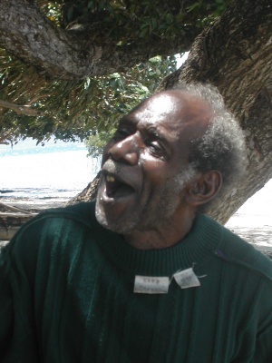
Our friend, Manse
Our first stop around Malekula was at Awei Island – the westernmost of the Maskelynes. We expected a quiet anchorage to ourselves, but we found a windy bumpy anchorage with three big catamarans. But there was room enough for all of us, so we tucked in as best we could.
Shortly after we arrived, an old man paddled out in an outrigger canoe and introduced himself as ‘Manse’. Although his English was limited, we understood (and saw) that he had a badly swollen foot, and he wanted some ‘medicine’ for it. Apparently he had stepped on something a few days prior. We looked at the wound and found an ugly oozing puncture on the ball of his foot. We soaked it, cleaned it, and dressed it. And while his foot was soaking, we got to know him a bit.
We thought that Awei Island was uninhabited, but Manse moved his extended family there a few years ago. We wanted to check on his foot the following day, so Manse invited us to come visit him on his island.
We beached the dinghy on a small sandy beach about 30 yards from the boat. There is only one trail on the island, so we couldn’t get lost. We walked along ironwood trees, tidal pools with cool creatures, numerous garden plots, and breathtaking scenery.We expected to find three of four buildings, but we found a small traditional village. There are five or six dwellings, and they have built a well, church, and drying shack. There are even a few benches in various shady spots with great views. And the views…
Manse’s foot looked much better, and he was experiencing much less pain. He felt well enough to show us around, then we sat in the sand on the beach and talked and laughed for a few hours. This was one of those times that remind us why we are out here doing this – to meet men like Manse and enjoy places such as his home.
We also met two of Manse’s children and many of his grandchildren. They came out to the boat and brought us bananas, papayas, mango, lemons, limes, ‘snake beans’, kumara (sweet potato), pomelo (grapefruit), and bok choy. They were all very nice.
But the end of the season was approaching, and we needed to head north. So we said a fond goodbye to Manse and headed north for Banam Bay on the southeast coast of Malekula. However, it was quite rough outside, and we had our dinghy in tow, so we decided to tuck in along Sakau Island for a night or two.
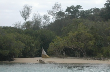
Sailing canoe on beach
The beach on Sakau Island
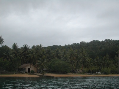
Sakau is a pretty little island with a small community center, a health clinic, and a few hundred people. We were surprised to find a few moorings there, and we tied up to one. We were pleased to learn that their Chief, Willie, is involved in various conservation efforts, and he has designated much of the island a reserve. He has designated the anchorage area just offshore a giant clam reserve, and moorings were installed to prevent anchor damage to the clams.
Chief Willy told us that there was a wreck of a former copra boat in the shallows just offshore, and we were welcome to dive it. It was a nice dive with a surprising variety of fish life; however, there were very few clams.
It took us only 2 1/2 hours to get around to Port Sandwich, and the bay was empty when we arrived. That gave us our choice of anchoring spots. We went way inside and temporarily anchored in 23 feet of water over a mud bottom. Xavier was growing in intensity and heading directly for us (still over 300 miles away), so we quickly set about readying Passage to face the onslaught.
We laid out two anchors. We first set our FX-37 Fortress anchor followed by 40 feet of chain. That chain attached in series to our 65 pound CQR on 300 feet of chain. We decided to keep our 44 pound Bruce on the bow in case we needed to throw out another anchor quickly.
Then we completely stripped the boat. We removed all sails and skyed all halyards. We removed solar panels and wind generator. We put away the dinghy, outboard, barbecue, and everything else that might create windage. We even removed our netting along the bow lifelines. Everything was stowed in either the lazarette or the forepeak.
Path of Cyclone Xavier
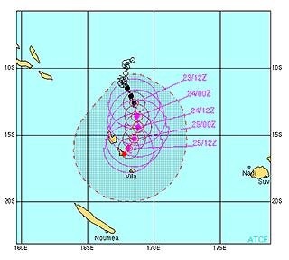
Black dots are actual positions purple dots are predicted positions red dot is our position
Seven other boats had come in seeking shelter in Port Sandwich, and there was a collective sigh of relief as Xavier wound down. It was the birthday of one of the women on SS Alvii, so they hosted a combined cyclone/birthday party that was a lot of fun.
We had been visited a few times by a local old guy whom lives on shore near where we anchored. He had invited all of the boats to come ashore to visit, and we went along with three other boats. This family has quite a spread, and we enjoyed spending a few hours with them. But we needed to put Passage back together.
Local string bank on SS Alvii
Follow us to Espiritu Santo or return to our Vanuatu page.