GALAPAGOS ISLANDS

The Galapagos Islands are part of Ecuador. The islands are one of twenty provinces of Ecuador, but they are 600 miles offshore from the mainland. The islands are quite different from the mainland despite their affiliation. We did not visit mainland Ecuador, so we are discussing only the Galapagos Islands, and not mainland Ecuador here.
Galapagos is Spanish for tortoise, and there are many tortoises in the islands. The islands are also sometimes called the Archipelago do Colon. Either name refers to these isolated and unique islands straddling the equator in the Pacific Ocean.
It is not clear whether or not South American Indians visited these islands prior to the 16th century. Some remains of old potsherds were found in the islands. But no one has found any graves, ceremonial vessels, constructions, or other evidence of human habitation. It seems unlikely that the islands were inhabited prior to the 16th century.
The Galapagos Islands were found by accident in the 16th century – specifically 1535 – when a ship carrying the Bishop of Panama to Peru drifted off course and came upon the islands. The islands were named the Islas Encantadas – Enchanted Islands – and they went by that name for the next 300 years.
In the 17th and 18th centuries, the islands were visited by well known explorers including Captains Drake, Raleigh, Cook, and Hawkins. They were also used as a base for pirates, whalers, and sealers. Ships stopped at the islands for refuge and provisions. Giant tortoises were loaded in to ships’ holds where they would survive for months without food and water. They were later used for fresh meat for the crews. Thousands of tortoises were taken aboard passing ships, and some species became extinct. British and American whalers also killed thousands of Galapagos fur seals.
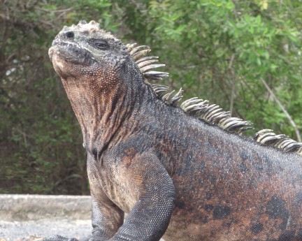
Marine iguanas
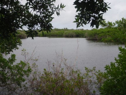
Many lagoons
Two particularly noteworthy events occurred during the 19th century. The islands were annexed by Ecuador in 1832. Then only three years later, in 1835, they had their best known visitor – Charles Darwin aboard HMS Beagle. During Darwin’s five week stay there, he observed the unique surroundings of the environment and noted the unique development of the wildlife. These findings contributed much to his theory of natural selection.
In the early 20th century, Ecuador considered selling the islands to ease their fiscal problems. Because of the islands’ strategic location in relation to the Panama Canal, the United States sought to buy them for military use. That sale/purchase did not occur. During World War II, the US did, however, establish a naval base on Baltra Island and numerous radar stations throughout the islands. All military facilities were given to Ecuador when the war ended.
Although the Galapagos have some unique flora, they are known for their unique and tame wildlife. All native mammals, reptiles, and birds are protected.
They have only two native land mammals (two species of rice rat), but they have numerous marine mammals, reptiles, birds, and fish. Their marine mammals include sperm and killer whales, bottlenose and common dolphin, two species of sea lions, and fur seals. All of their reptiles except the sea turtle are endemic to the islands. They include the giant tortoise, lava lizard, land iguana, and marine iguana. Their birds include the Galapagos penguin and the flightless cormorant. Their fish include sharks, tuna, lobster, and crayfish.
The islands are trying to preserve this unique flora and fauna which has been threatened by introduced species, illegal fishing, and development. The first protective legislation was enacted in 1930. In 1959, all land in the islands was declared national park. Tourism in the islands – a substantial source of income – began in the 1960s and brought its inherent problems. Subsequently, 27,000 square miles of ocean surrounding the islands was declared a marine reserve. This is second in size only to Australia’s Great Barrier Reef. In 1978, the islands were declared a UNESCO World Heritage Site.
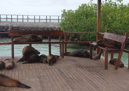
Sea lions on the dinghy dock
Despite these efforts, the early 21st century showed that all was not well. In 2007, UNESCO put the islands on the list of ‘World Heritage Sites in Danger’. By 2010 they were removed from that list after showing substantial improvement in conservation efforts. But conservation issues remain. The island population is growing excessively. Invasive species have not yet been adequately controlled. And the islands suffer terribly from environmental events beyond their control. El Nino events occur every three to seven years with devastating effects on some wildlife. During the 1982-3 El Nino season, 70% of the marine iguanas starved to death. Efforts are ongoing and substantial to preserve this natural wonder.
Today, the islands and their surrounding water form an Ecuadorian province, a national park, and a biological marine reserve.
The Galapagos Islands include 13 main islands and several small islands spread over 17,000 square miles of ocean. These islands are of volcanic origin, and they are geologically young. The islands span the equator with a distance of 137 miles from the northernmost island of Darwin to the southernmost island of Espanola. They lie astride the converging El Nino Current from the Gulf of Panama and the Humboldt Current from the south. These currents flow side by side to the west-northwest around the islands. The water in the north is often 80° when the water in the south is only a chilly 60°. The climate is usually cooled by the Humboldt Current.
Their total land mass of the islands is 3,093 square miles. The coastal areas are dry, and the interiors are mostly damp and dense with vegetation.
The Galapagos have no indigenous population, and the first permanent resident established himself on the island of Floreana in the early 19th century. Today, the population is mostly Mestizo, and only five of the islands are populated. The population is approximately 27,000, and the main population settlement is on Santa Cruz Island.
They speak Spanish, but some English is spoken by many with any links to the tourist industry.
There are efforts to control the rapidly growing population which has been increasing at an unsustainable rate of 8% per year. Previously no permanent residency was allowed for non-Ecuadorians, but now not even all Ecuadorians can get permanent residency. One must have a close family link to the islands to get permanent residency. Time will tell how this policy curbs their excessive population growth.
Tourism in the Galapagos began in the 1960s, and it has become its major source of revenue. The National Park Service employs many local residents as ‘guides’ whom are required to accompany visitors to most sites. Many others make their living running tour boats or small restaurants. Tourists support the Galapagos. The local currency is the US dollar.
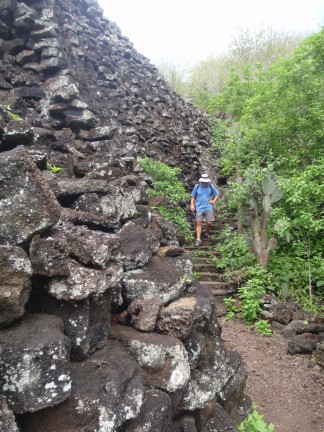
Wall of Tears
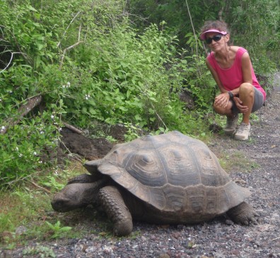
Giant tortoise
The Galapagos Islands are a province of Ecuador. The administrative center for the islands is on San Cristobal Island.
It was once nearly impossible for a sailboat to get permission to visit the Galapagos Islands. Now it is expensive and bureaucratic, but it can be done. One can apply for a cruising permit that allows them to visit three islands – San Cristobal, Santa Cruz, and Isabela – or visit one island without a permit. The permit is expensive and tedious to obtain, so we chose to visit only one island. Based on the experiences of friends, we chose to visit Isla Isabela.
We arrived at Isla Isabela at Puerto Villamil on the southeast tip of the island. This port is named after General Jose de Villamil who was the first governor of the Galapagos. Puerto Villamil is the 3rd largest settlement in the islands. This is the only port on Isabela where visiting boats are allowed to anchor, and it is a very bumpy anchorage. After our bumpy trip from Panama to the Galapagos, we were hoping for a restful anchorage, but it was not to be. We bounced and rolled our entire time there.
The government requires that visiting boats use an agent for checking in and out, so we hired the island’s only agent – JC DeSoto. He was a pleasure to work with. He walked us through the extensive paperwork and explained the $730 USD fees that were unavoidable. He also gave us lots of valuable advice and helped us solve a few minor problems.
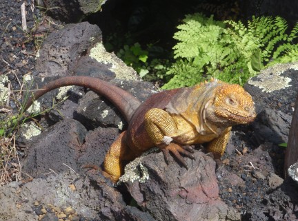
Land Iguana
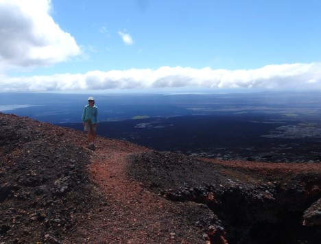
Atop Vulcan Chica looking northward
The island has trucks but no cars that drive on dirt roads. We hired a truck taxi a few times when we traveled a long distance out of town, but we were within walking distance of town. Town had a few small groceries, numerous local restaurants, and tourist outlets through which tours could be arranged. The groceries were hubs of activity when a ship arrived from the mainland with fresh produce. Most of it would be sold within six or eight hours. We learned to go ashore when a supply ship arrived. The local restaurants all served similar fare. It was ok but nothing special. And the tourist outlets were a necessity because all of the island is national park, and a park guide or ranger is required to explore the park/island. One must hire a guide to visit most – but not all – places outside of town.
We were able to visit el Muro de las Lagrimas (the Wall of Tears) without a guide. Although it is only a few miles out of town, it is up a steep hill. So we hired a taxi to take us there (uphill), and we walked back. This is the remnant of a penal colony that incarcerated men from 1946 till 1959. As punishment, the men built a 65 foot high wall from volcanic rock that they dug and carved. Reportedly thousands died constructing this wall. They also constructed steps leading up to the top of the surrounding hill with a breathtaking view. It is difficult to reconcile the beauty of the surroundings with its tragic past. As we walked back (downhill), we saw numerous giant tortoises.
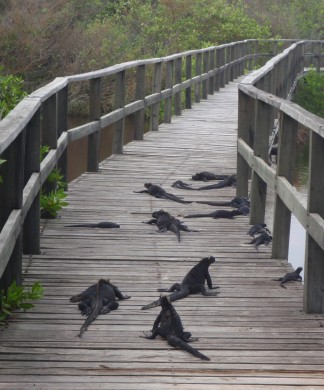
We were also able to go to the Tortoise Breeding Center without a guide. One can get there by road or by walking along a boardwalk built over lagoons with marine iguanas, flamingos, lava lizards, ducks, and lots of birds. This is home to many thousands of tortoises in all stages of life. On Isabela, each of the six volcanoes has its unique species of giant tortoise, and all six species are breeding at the center. The tortoises are eventually released in to the wild. Unfortunately we went on a weekend when no employees were available to answer our questions.
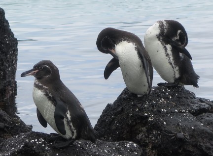
Galapagos penguins
We also hiked up to Vulcan Sierra Negra, and this trip required a guide. We had heard that it was five miles each way, but we think it was more. When we started the hike, it was raining, and the ground was very muddy. We hiked up the volcano for an hour or two, and it was not raining, but it was very foggy. We stood on the rim of the caldera, and we could see nothing at all. So we carried on over the ridge and downhill to Vulcan Chica. (Maybe it is five miles to Vulcan Sierra Negra but further to Vulcan Chica?) This was a spectacular view just above the ‘waist’ of the island. We rested there briefly, then we had a very rugged hike out. When we got back to Vulcan Sierra Negra, the caldera was still completely fogged over. We trudged through the mud the rest of the day.
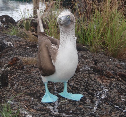
Blue-footed booby
We had been told that the best trip on the island was to an area called the Tunnels. This trip requires a boat and a guide, and we did two snorkels and a rock walk. We motored west for 45 minutes to an hour to or first stop. We snorkeled with many rays (manta, eagle, golden, sting), turtles, reef fish, and thirteen whitetip reef sharks. We motored a bit further and got in very cold water for another snorkel with galapagos penguins, turtles, and seahorses. We were too cold to stay in the water for long at this site. Then the boat made its way through volcanic rock and tied up to a chunk of rock where we disembarked. We went for a wonderful walk on the rock. There were bluefooted boobies all around doing their mating rituals, and they seemed oblivious to us. The terrain was spectacular, and we cannot believe that someone can drive a boat in there! This was quite a trip.
The bluefooted boobies were not unique in their lack of fear of man. Almost all of the animals on Isabela essentially ignored us. All wildlife is protected, and the animals do not seem to fear man. That creates a special opportunity to see these animals up close and for extended times.
But we had a very long passage ahead of us (more than 3,000 miles) to French Polynesia, and we needed to prepare. We were very disappointed to learn that there was no diesel available on the island, nor was there any propane. We needed both. We were able to buy some ‘black market’ diesel, but there was no propane to be found. We also needed to repair our torn sail, and it was bigger than we could do on the boat. JC helped us locate a few local women that were willing to do it, but various issues prevented us from using them. So we sailed off with adequate diesel, limited propane, and a badly torn genoa. But we were elated with the experience we had on Isabela and her wildlife. The Galapagos were all we expected and then some!
Sail with us from the Galapagos to French Polynesia
or jump ahead to French Polynesia