THAILAND TO SRI LANKA
After more than three years between Langkawi, Malaysia and Phuket, Thailand, we finally left southeast Asia. Our plan was to leave early in the season so that we could afford the time to make stops along the way to the Mediterranean – our final destination for the 2011 season. We left Yacht Haven Marina on Phuket on Wednesday, January 5 – an early start, indeed. We sailed around to Nai Harn Bay on the southwest tip of the island with plans to spend one night. We wanted to navigate our way through the offshore fishing fleet by day light. But it was blowing a bit more than we like on January 6, so we stayed put for one more night. We said our goodbyes to Thailand in the early morning of Friday, January 7, and we headed west.
We expected this to be an eight day passage of approximately 1,100 miles along the rhumbline. However, we started making course deviations shortly after leaving Phuket. The rhumbline would have taken us through Sombrero Channel in the Nicobar Islands, and we decided to go a bit further south and go around the bottom of Great Nicobar Island with fewer hazards and fishing boats to pass.
It took us two days to reach the Nicobars, and during that time our sailing varied from a beam reach to wing-and-wing down wind. We also motorsailed a lot, and we saw many dolphins. Although we passed within 14 miles of the southern tip of Great Nicobar Island, we never saw the island or the light on its point. We did, however, see many ships’ lights to the south of us. It appeared we were traveling about 8 miles north of the shipping lanes.
We were already experiencing some equipment problems that would continue through this passage. We had problems with our radar, AIS, and watermaker – all three important items.
Our radar is an older model Furuno, and it would not tune. For a while, we could get it to tune if we had a visual on a target, but we could not rely on the radar to find targets that were out of visual range. And this problem got worse as the days wore on. By the time we arrived Sri Lanka, we could not pick up a steel ship within a few miles of us. We needed to replace our radar.
Our AIS is an embarrassing story. We knew it had stopped working, and we forgot about it. We got busy with so many other things that we both simply forgot that it had not been working. We could make this trip without it, but we knew we would prefer to have it.
And our watermaker is vital to any long distance passage – particularly the places we are traveling this year. We knew that we must get the watermaker back in good working order before leaving Sri Lanka (we rationed our water until we got to Sri Lanka).
We contacted our dear friend, Greg of SV Sonrisa, and he started working on these issues for us from afar. He put us in touch via e-mail with the manager of his local West Marine, an electronics supplier, and a tech from Spectra (watermaker). By the time we arrived Sri Lanka, we had a pretty good idea what we needed to do next – and that included ordering a new radar and AIS. But we had many interesting miles to cover before arriving Sri Lanka.
On our fourth morning – January 10 – we had a series of fronts blow over us. They brought rain and stirred up the seas. We were aware of a persistent low pressure system just off the southeast coast of Sri Lanka, so we decided to detour a bit to the north to stay on the north side of this as it moved eastward and possibly a bit northward. We wandered about 90 miles north of our rhumbline. We never had winds above 28 knots, but our seas got big and ugly for four days and nights. The seas, from the south and southwest (as expected) were 12 to 15 feet at times. And the currents became even more problematic. We had the strangest currents we have experienced with frequent changes in intensity and direction. With the combined seas and currents, we were making less than 2 knots through the water at times. We were not happy campers, but there is nothing one can do but to forge ahead and get through it. So we did.
During one of our nights with the uncomfortable seas we had a flock of terns land on the boat. Bud viewed them as an amusing diversion (we needed both amusement and diversion). Nita viewed them as flying poop factories. We were both right. Although they were somewhat cute to watch, they became an issue during Nita’s late night watch. Lots of things were happening all at once, and she called Bud up to help. Two of the terns had settled on the cockpit sole, and there was bird shit all over. This did not enhance the situation.
On our seventh morning, we heard VHF chatter from other sailboats. They were talking about having survived a few days of a ‘storm’ running under bare poles, and they were just getting underway again. One boat, SV Bacchus, had been abandoned and lost (the crew was picked up by a passing freighter). Because these boats were in VHF range, they were obviously nearby, but we did not know anything about a storm. Our conditions had been uncomfortable, but definitely not a storm. We figured we would learn more when we arrived in Sri Lanka.
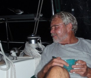
Bud amused by one of many visiting terns
We approached the southern tip of Sri Lanka – Dondra Head – with some trepidation. The bank just before the point – Basses Reef – has a history of 6 knot currents, but they were mild when we passed by. And the point has a history of 35 knot winds, but they too were light when we rounded it. The winds were so light that we had to motor, and we started experiencing fuel problems. The engine rpms would drop then surge then settle again. We had fuel. Now what?! We had heard that the shipping traffic around the point was intense, but it was not. The fishing boats, however, were unbelievably thick. But we picked our way through them – thousands of them – and approached Galle Harbor in the early morning of Sunday, January 16.
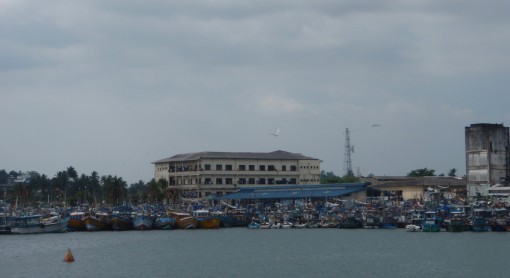
Approaching Galle Harbour
It took us 8 ½ hours to travel from Yacht Haven Marina to Nai Harn Bay on the southwest tip of Phuket. It took us nine days six hours to travel from Phuket to Galle Harbor. In all, this leg was 1,175 miles, and we spent 230:45 hours underway. We motored more than half of that time – 132 hours. We burned 93 gallons of fuel at an average rate of .7 gallons per hour. That’s a lot of motoring and a lot of fuel!
The check-in procedure was not a good one, but we will discuss it on our ‘destination’ page. However, the ‘storm’ that other boats experienced warrants a bit more discussion of what we learned after arriving.
Boats that left two to four days ahead of us and sailed a similar course were hit. Also, boats heading southwest from the Andaman Islands were hit. The collective info we have gleaned is that the boats that approached the southeast coast of Sri Lanka – where the persistent low was enduring – were chased well north in winds that were sustained at 45 knots and gusting to 55 knots. Many sails were blown out, and boats sustained lots of minor damage. We have superimposed MaxSea tracks of boats hit by the storm over our track, and they were remarkably close. All we can figure is that we got lucky in the timing. Nothing in the weather forecasts indicated that this low would develop in to a storm, but it did.
As usual, we were glad to reach the end of a passage.
Follow us as we visit Sri Lanka.