TONGATAPU
Sailing doesn’t get much better than this. We had twelve to fifteen knots of wind on or just forward of our port beam all day. We sailed with a full main, 100% #2 jib, and staysail. Seas were only one foot – just enough to create a gentle rocking motion. We had about 50% cloud cover most of the way – just enough to provide some shade and relief from the heat. Just about perfect.

This fish was much bigger than he looks from this camera angle
Although we had a frig full of tuna from fish slayer’s recent adventures, we tossed in two lures anyway knowing that we could give away any excess fish in Tongatapu (this is the first time we have tossed in two lures – we usually use just one). About an hour north of our first Tongatapu landfall – Malinoa Island – Nita checked one line (we just use handlines) and found it had a fish on it. It appeared to be a wahoo of about 2′ length, but as it approached the boat, it severed the monofilament leader and escaped with her favorite pink lure. Fish slayer checked the other line, and he too had a wahoo. This was a big boy on a big lure with a wire leader, so it was not likely that he would get away.
It took a while to get this wahoo to the boat, and it took equally long to get him subdued and on board. This is the first fish we have caught that fish slayer could not land himself. It took both of us to get him up over the rail. Then fish slayer couldn’t lift him off the deck for a picture. Our best estimate is that this fish was about 4 1/2 feet long and weighed in the neighborhood of 50 pounds.
When Nita took a picture of fish slayer and his fish, he could not lift it off the deck, so the fish’s lower body and tail are laying on deck. Unfortunately, the camera angle used doesn’t show that, and the fish looks considerably smaller than he was. But he was very very big!
By the time the fish was cleaned, and we had a bucket full of fillets, we were close to Nuku’alofa but closer to Malinoa, so we decided to stop at Malinoa for a night before heading to Nuku’alofa. What a great day!
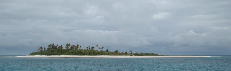
We didn’t really plan on stopping at Malinoa. We had planned on sailing from the southernmost Ha’apai island – the beautiful Kelefesia – in to Nuku’alofa. But it was getting late in the day, and we decided to end a great day of sailing in a beautiful and isolated anchorage that we could have to ourselves. Malinoa was just right.
Malinoa is just a dot on the chart about six miles north of the harbor in Nuku’alofa. It is very tiny – probably just a few acres – but what it lacks in size it makes up for in beauty. It is lightly wooded, and a sandy beach surrounds it. There are substantial coral reefs all around it, and there are plans to turn this island in to a protected marine preserve. We think that is a great idea if it will help preserve this island in this ‘untouched’ state.
It took some effort to navigate our way in, but it was well worth the effort. We had to go in quite close to find a sandy patch in which to drop our anchor, and we ended up dropping in only 18 feet of sand. The crystal clear water revealed spectacular corals all over the bottom, but we did not get in (we were again pushing the envelope on being ‘legal’). We were content to look at it through a few feet of clear water. We had a calm quiet night here before heading to the bright lights of the ‘big city’ (a relative term) of Nuku’alofa.
Tongatapu is the southernmost island group in Tonga. It is also the name of the island on which Nuku’alofa – the capital of Tonga – is located. So, in an effort to minimize the inevitable confusion this causes, we will refer to the island group as Tongatapu and the island itself as Nuku’alofa. We do this knowing full well that there is much more to the island than just its capital city. However, we visited only the capital on this island, so this seems a workable way to organize our experience.
Tongatapu – meaning “sacred south” – is the government and cultural center of Tonga. The Tongatapu group – approximately 160 square miles – comprises one third of the land mass of the Kingdom. Approximately two thirds of the Tongan population live on these islands in 60+ villages. Depending on the source, there are between 30 and 46 islands in the group (just how big does a rock have to be to be called an island?). Much of Tonga’s early known history occurred in the Tongatapu group. Today, the capital of Tonga remains in Tongatapu.
We had a somewhat ‘distant’ relationship with Nuku’alofa – the capital of Tongatapu. We chose to stay across the bay at Pangaimotu Island while waiting for a weather window to head south to New Zealand.
You can return to our Tonga page or follow us as we sail to New Zealand.