SOCIETY ISLANDS
The Society Islands are a group of islands forming the westernmost part of French Polynesia. There are twelve major islands and two small islands that extend more than 400 miles from the southeast to the northwest.. The islands are geographically and administratively divided in to two groups – the windward and leeward islands.
The windward group (the southeastern half of the Society Islands) includes five major islands: Tahiti, Mo’orea, Mehetia, Maiao, and Tetiaroa. Four of those are high volcanic islands, and Tetiaroa is an atoll.
The leeward group (the northwestern half of the Society Islands) includes seven major islands.Four are high volcanic islands: Raiatea, Tahaa, Huahine, Bora Bora, and Maupiti.One is almost an atoll: Maupiti. And two are true atolls: Tupai and Maupihaa. The leeward group also includes two small islands: Manuae and Motu One.
The Society Islands were formed after the Tuamotus but before the Marquesas. They have fertile coastal plains of volcanic ash for agriculture including copra, pineapple, vanilla, and fruits. They also have protective barrier reefs that shelter the inhabited shorelines. The total landmass of the islands is 610 square miles, and the highest point in the islands is Mount Orohena on Tahiti at 7,352 feet.
All islands are populated. The total population is approximately 230,000.
We arrived in the Society Islands in the windward group. We first made landfall at Tahiti, then we then sailed to Mo’orea. Then we sailed to the leeward islands of Raiatea, Taha’a, Huahine, and Bora Bora. We will discuss the islands in the order in which we visited them.
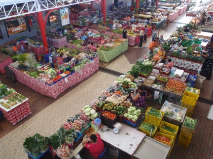
Grand Marche, Papeete, Tahiti
Tahiti is the largest of the Society Islands with 400 square miles of land. It is formed by two volcanoes which meet at a narrow isthmus – the Isthmus of Taravao. Tahiti Iti is the smaller lobe to the southeast, and Tahiti Nui is the larger lobe to the northwest. The interior of the island is rugged and uninhabited, but the coastal belt is heavily populated. There is no village structure here like in the outer islands. Instead, homes are strung along the coast.
Tahiti’s total population is approximately 170,000, and three quarters of them live in Papeete – the capital of the Society Islands. Papeete is also the distribution center for all of French Polynesia’s islands. It is a busy and crowded city.
We were tired when we arrived Tahiti – we were especially tired of making passages this season. So we stayed on the boat and did very little our first day there.
The next day was Bud’s birthday, but he was not enthused. We went ashore and ran errands. We made a scouting trip to the airport (we would be flying through there in a few weeks), and we took the bus in to Papeete. We finished checking in and found fuel filters on our walk. We had a terrible lunch at the Grand Marche (tasteless oily chow mein inside a soggy baguette), and Bud just could not get enthused to do anything for his birthday (we really were tired). We returned to the boat to find a birthday surprise from SV Big Rock including an invitation for cocktails on their boat the following evening. We accepted and had a great time.
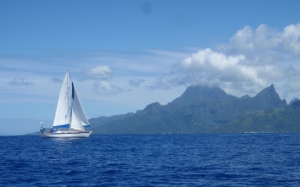
SV Big Rock sailing from Tahiti to Mo’orea
We got a bit more energetic over the next week. Bud spent a day in the engine room polishing fuel and changing filters. Will this finally be the end to our fuel problem? Nita got the boat cleaned up and put back together. We made a few trips in to Papeete and enjoyed it. We were thrilled to have access to all the fruits and veges at the Grand Marche. Our friends, Jesse and Shay, on SV Big Rock were also in the anchorage, and we went together to the Museum of Tahiti. It was small but nice.
Tahiti did not overly appeal to either of us. It was too crowded and busy (not to mention expensive!). So we spent a lot of our time planning our haul out which was now just a few weeks off. On August 27, we fueled at Marina Taina and left for Mo’orea at 0930 local time.
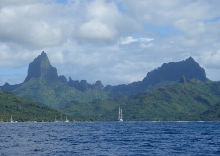
Approaching Opunohu Bay, Mo’orea
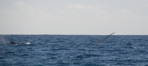
SV Big Rock was also sailing from Tahiti to Mo’orea this day, and they left just ahead of us. It took us an hour to make our way out the channel, and we had dolphins swimming with us in the harbor and channel. We had a very slow relaxed sail with a full main and #2. We added our staysail for a while. We enjoyed taking lots of pictures of SV Big Rock as we sailed close by. And we had humpback whales breaching off our starboard beam when just a few miles off the north coast of Mo’orea. We spent five hours and fifty minutes sailing twenty six miles for an average speed of only 4.5 knots. A very relaxing sail.
Mo’orea means ‘yellow lizard’ in Tahitian. In times past, it has also been known as Aimeho and York Island. The island is only 12 miles northwest of Tahiti, and there is frequent ferry service from Papeete, Tahiti to Vai’are on the east coast of Mo’orea. It is volcanic in origin, and its area is only 52 square miles. The highest point on the island is Mount Tohi’e’a at 3,960 feet. This point is in the center of the island, and it is visible from most places on the island. The island’s population is approximately 17,000.
There are two small but beautiful bays on the north coast of Mo’orea with decent anchorage. The bay to the east is Cook’s Bay. The largest commune of Mo’orea – Pao Pao – is at the bottom of Cook’s Bay, and the bay is sometimes called Pao Pao Bay. An interesting part of Cook’s Bay is the Richard B. Gump South Pacific Research Station which is maintained by the University of California, Berkeley. This is a multi-institutional site to study long-term ecological phenomena. To the west is Oponohu Bay. Two small communes – Piha’ena and Papeto’ai – are on Oponohu Bay. Opunohu Bay is the site of another research station studying coral reefs and fish populations throughout French Polynesia.
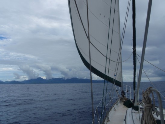
We headed for Opunohu Bay, and as we approached we saw many boats – twenty? – anchored outside the bay, but there were no boats inside the bay. We went inside, and it was spectacular. SV Big Rock followed us in, and we both anchored in the center of this breathtaking scenery. Our view to the south was Mount Tohi’e’a (3,960′) on our left and Mount Moua Roa (2,499′) on our right. Mount Moua Roa is often called Bali Hai as this was the setting for the movie South Pacific. We had a bit of rain that kept us on board, and we enjoyed the view.
When the rain stopped, we took the dinghy to the village of Papeto’ai to the west. We found a small grocery with a few staples, but the highlight of the day was watching and listening to a local hula troupe practicing. It was very casual in someone’s front yard, but it was a nice local experience. Another day we walked from Papeto’ai to the northwest corner of the island. The walk was beautiful, and we made a few stops along the way at a woodcarver’s shop, a grocery, and a restaurant for lunch.
Two humpback whales off Opunohu Bay, Mo’orea
Another day we took the dinghy to the east and in to Cook’s Bay. We picked our way through some very shallow water, and it took us 1 1/2 hours to get there.We saw one black tip shark in the shallows, and we did not get rained on. We found about ten boats anchored in Cook’s Bay. Cook’s Bay offers conveniences that are not available in Opunohu (shopping, gas station, etc.), but we much preferred the beauty of Opunohu. And since it was Sunday, almost everywhere on shore was closed, so we did not get to enjoy those conveniences. Lunch was junk food from a mini-mart. Fortunately we found the shallow pass on our return to Opunohu, and it was a much easier trip.
And on another day we explored the bay by dinghy. We motored around the shoreline and saw three small manta rays close behind SV Big Rock. We went up the small river that dumps in to the bay and saw local housing. It was a nice peek in to local life.
We have two intense memories of Mo’orea. First is its beauty. The sky was usually clear. The land was dramatic terrain covered in green. The water was turquoise blue and clear with many fish. And the other intense memory is the scent of frangipani. Almost every night, while sitting in our cockpit, we could smell frangipani. – not just a subtle whiff but a strong scent. Mo’orea is what people think about when they fantasize about the south Pacific. It is a beautiful place.
But we had a date with a boatyard in Raiatea, and we needed to move on. So we left Mo’orea on September 2 heading for Raiatea.
Sailing to Raiatea
Mo’orea to Raiatea is too far to go on a day sail, so we left knowing this would be an overnighter. As soon as we left Opunohu Bay we had big winds (to 26 knots) and seas (to 10′). These persisted for a few hours. The winds began to decrease, but the seas did not, and it became quite rolly. We also had a few squalls and a 30 degree wind shift. The wind continued to back, so we changed our plans. We had planned on going around the southern tip of the island, but we decided to enter the lagoon on the eastern side – further to the north. After a bumpy night, we entered the pass in to Raiatea’s lagoon at 0700 local time. It took us another hour to go up around the top of the island and down the western side to the boatyard. We were surprised at how poorly marked this pass was, but we went slow and picked our way through it. When we were in the vicinity of the boatyard, we spent another hour looking for a place to anchor. It was too deep – between 70 and 100 feet. We finally contacted the boatyard, and we were told that we could pick up one of their moorings. By the time we finally got secured on the mooring, we had traveled 116 miles in 21 hours for an average speed of 5 1/2 knots per hour.
This would also be the end of our sailing season for this year. We ended the season with 6,606 nautical miles under our keel.
Ancient Polynesians considered Raiatea the cradle of their thousand-year old civilization. Its ancient name was Havai’i Nui meaning Big Springing Water.
James Cook anchored at Raiatea in 1769 after Wallis had discovered Tahiti. Then in the early 19th century, Tamatoa III unified Raiatea and Taha’a, converted them to Christianity, and implemented a code of obedience to missionaries – a code which spread to all the Leeward Islands expect for Huahine. The Pomare family, the ruling family in Tahiti, was finally able to establish power over Raiatea and Taha’a under Tamatoa IV.
France recognized the independence of the Leeward Islands in the mid-19th century, but they sought to annex the islands in the latter part of the century. War raged for ten years, and Raiatea and Taha’a eventually surrendered to the French.
Raiatea and its neighbor island, Taha’a, are enclosed within one lagoon, and it is believed that they were once one island. Raiatea has about 65 square miles of land, and Taha’a is 35 square miles, so their total land mass would have been around 100 square miles – still only about one fourth the size of Tahiti. Both islands have high mountain peaks.
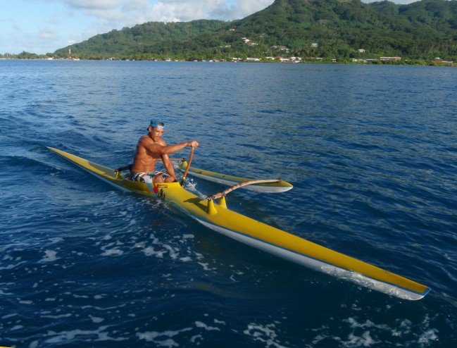
Paddler riding our wake
Raiatea means ‘bright sky’ in Tahitian. Although it is the second largest of the Society Islands – second in size only to Tahiti – it is still not very big with a total area of less than 65 square miles. It is, however, the most populated island in the Leeward Islands with around 12,000 residents. More than 10,000 of those live in the commune of Uturoa. There are nine passes in to the lagoon around Raiatea, and its highest peak is Mt. Tefateaiti at 3,333 feet.
Raiatea’s economy is mostly agricultural with crops of vanilla, pineapple, coconut, and noni. They have two boatyards, and they are slowly building an industry around visiting boats. Raiatea was previously the administrative center of French Polynesia; however, that is now Tahiti. Raiatea is probably also the ancient Hawaiki – the source of Hawaii’s second wave of immigrants (the first was probably from the Marquesas).
Raiatea was less developed than we expected. We were only a few miles outside Uturoa, and we found only a few services on the west side – two small groceries, one restaurant, no bus. We walked to the airport for a scouting trip one day, and we took a taxi to town another day. Town, and its provisioning opportunities, were ok. Just ok.
We had lots of wind and rain, so we took advantage of the time to get ready for our haul out. Also, we learned that there was a current epidemic of dengue fever on the island, including four boats in the boatyard, so we wanted to avoid exposure as much as possible. We stayed on the boat and got ready for our scheduled haul out on September 10. We removed sails between showers when the winds were down, and we worked below when it blew and/or rained.
This was a unique haul out experience for both of us. We have previously had Passage lifted by a travel -lift and placed on supporting stands. Here they use an in-water cradle. The cradle is backed in to the water, and you drive the boat on to the cradle. One line is held forward just to keep the bow centered. Two divers are in the water wearing only masks – no fins, snorkels, etc. The divers set the stands underwater. A line is placed around the stern ‘just in case’ something slips, and a tractor drags the boat/cradle unit up a steep ramp to dry land. It was not as scary as we thought it might be.
The wind continued to blow, and the rain continued to fall. The rain made it a bit difficult to get Passage ready to leave because we could not put away deck gear that was wet. But we did the best we could, and we were ready to leave on September 12.
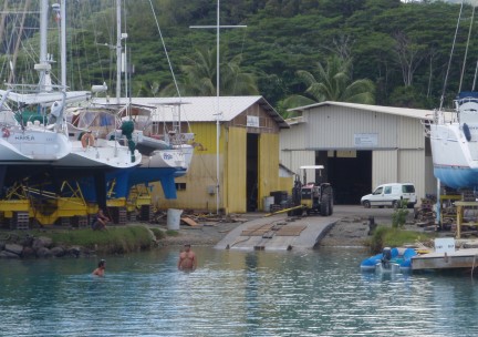
Haul out ramp at Chantier Naval on Raiatea – note divers
We went to a hotel on the northeast corner of the island for one night before flying back to Hawaii. It was an interesting and very expensive experience.It reminded us how fortunate we are to experience new places from our boat. But we had experienced enough new places for one season, and we looked forward to returning to Hawaii for a few months.
We returned to Raiatea on April 19, 2015. We were disappointed that Passage did not fare the season as well as she usually does. We had lots of mold problems, and we also had some significant gear problems. They would take us a few weeks to sort out.
We got most of our problems solved, but our primary autopilot was dead, and we did not want to make our long passage back to Hawaii without it, so we needed to get a replacement. It would take one to two months to get it through Tahiti, so we ordered one from the US to be shipped to us in Raiatea. It was shipped via FedEx International Priority, and it made it to Tahiti in only six days. However, it took another ten days to clear French Polynesian customs and make it to Raiatea. Then we discovered that we needed three cables that were not shipped with it, so we could not install it anyways. But while waiting, we had time to explore a bit.
We rented a car and spent a day driving around Raiatea. It is 60 miles on a well maintained paved road, and it was beautiful! We visited the marai of Taputapuatea which was the political, cultural, and religious center of the Maohi civilization. We visited a small vanilla grower and learned a lot about vanilla. It is actually an orchid grown on a vine, and it must be hand germinated to produce beans. And Nita resisted buying any more pearls at the pearl farm where we stopped. We had lunch at one of the waterfront bungalow resorts, and we enjoyed the dramatic scenery. A lovely island.
We made a trip to Huahine for four days, and we bounced back and forth between Raiatea and Taha’a multiple times. We enjoyed both.
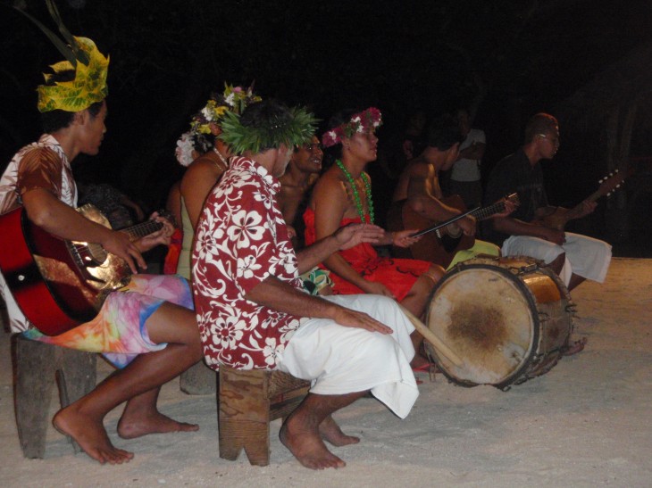
Local musicians on Taha’a
Taha’a shares a lagoon with Raiatea. It may have once been one island with Raiatea, and it shares many characteristics. Taha’a, however, is about half the size of Raiatea at 35 square miles. It, like Raiatea, has a high peak – Mt. Ohiri at 1,935 feet. Two passes lead in to the lagoon around Taha’a.
The population of Taha’a is around 5,300, and they live in eight small villages along the shore. The main village on the island is Patio on the north shore.
Taha’a derives much of its income from pearl farms and vanilla. There are a few guest houses and one very nice resort on Motu Tautau.
Our first of many trips to Taha’a was to the west shore – just off Motu Tautau. We had been told that there was a particularly good snorkel in the pass on the north side of the motu, and it was. We took along our new friend, Ken, from SV Grace. He and Bud snorkeled the very shallow pass (they both got a few scrapes) and Nita stayed on board Passage.
Motu Tautau also has a very nice appearing resort. All units are over-the-water bungalows, and they are quite private with private docks and ladders down to the water. We have never stayed at a resort like this, but this one was very nice.
But after just one long day, we returned to Raiatea. Ken needed to head to Tahiti, and we needed to continue our process of getting ready to head north to Hawaii. But we were still waiting for our autopilot, so we would visit Huahine while it was in transit.
We returned to Taha’a o May 15. We stayed in Apu Bay at the southern end of the island. It is a scenic bay although a bit busy with charter boats. We did boat chores while continuing to wait for our autopilot to clear customs.
We returned to Apu Bay on Taha’a twice more – once after a trip to Uturoa town on Raiatea to fuel and provision and again to watch a dance performance we had heard about. The dance performance was a buffet dinner as well. The food and dancing were both ok. The four dancers were 16 and 17 years old, and what they lacked in training/experience they made up for with youthful enthusiasm. But it was terribly overpriced – even by French Polynesian standards.
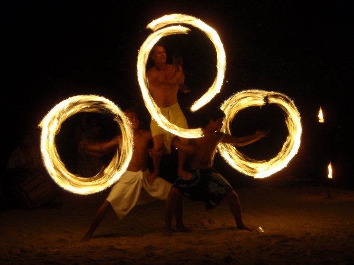
Fire dancers
At anchor on Huahine
Our trip from Raiatea to Huahine was 28 miles, and it took us 5 hours. We never had more than three knots of wind, so it was a motorsail.
Huahine’s history is similar to other French Polynesian islands. It is believed that it was first colonized around 850 AD by navigators from the west, and it was called Matairea which means happy breeze. Captain James Cook ‘discovered’ the island on January 30, 1769, and called it Hermosa. At that time, the queen of Huahine was Tehaapapa who was the great great grandmother of Pomare IV who would be Queen of Tahiti as a French protectorate. Christian missionaries arrived in 1808, and the island gradually converted to Christianity. It was annexed by France in 1897.
Huahine is a relatively small island comprised of only 29 square miles. It is ninety miles northwest of Tahiti. It is actually two islands connected by a bridge and surrounded by a common barrier reef with five passes through it. To the west of the bridge is Port Bourayne, and to the east is Maroe Bay. Sailboats cannot travel under the bridge.
The larger island to the north, Huahine Nui, is comprised of two volcanoes – Mt. Turi at 2,299 feet (the highest point on Huahine) and Mouatapu at 1,407 feet. The smaller island to the south, Huahine Iti, is formed by Mt. Puhaerei at 1,515 feet.
The population of Huahine is approximately 6,400, and they live a rural life in eight villages scattered about with four on each island. The main village is Fare, and it is on the north island. There is relatively little tourism on the island.
Huahine is known for growing melons. They grow cantaloupe and watermelon along the north coast. They also grow vanilla on inland farms as well as taro, banana, yams, and various fruits.
We made landfall on Huahine in a shallow anchorage just off Fare. We spent a quiet night there.
The next day we cruised by town hoping to pick up an internet connection and check on our FedEx package that was on its way, but we could not get connected. So we headed south. We went to Avea Bay on the southwest corner. This is a scenic bay with a few local houses and only one resort and restaurant ashore. It has a large shallow shelf just off the beach, and it made for fun dinghy exploration. We saw countless sea cucumbers, many reef fish, and one large ray. We had a nice dinner at Chez Tara – a charming little restaurant right on the beach. We were also learned that our FedEx package had arrived in Tahiti. Now to get it through customs…
The next day we moved three miles north along the west coast. We picked up one of three moorings just below the southern entrance to Port Bourayne. There was no development here, but there was again a shallow shelf worth exploring in the dinghy. There were many flowers floating in the water. We never did figure that out. This was a nice quiet night.
Sunset behind Tafa’a – taken from Huahine
The next day we went five miles back to the main village of Fare. We were impressed with multiple characteristics of this village. It was scenic, it had some services available (nice supermarket), and the people were very friendly. We bought a chunk of fresh yellowfin tuna about three inches thick and the diameter of a large dinner plate for the equivalent of $9.00 USD.
We were quite charmed with Huahine, but we wanted to get back to Raiatea with hopes that our package would be through customs (it took another eight days). We left Huahine early the following morning headed for Raiatea.
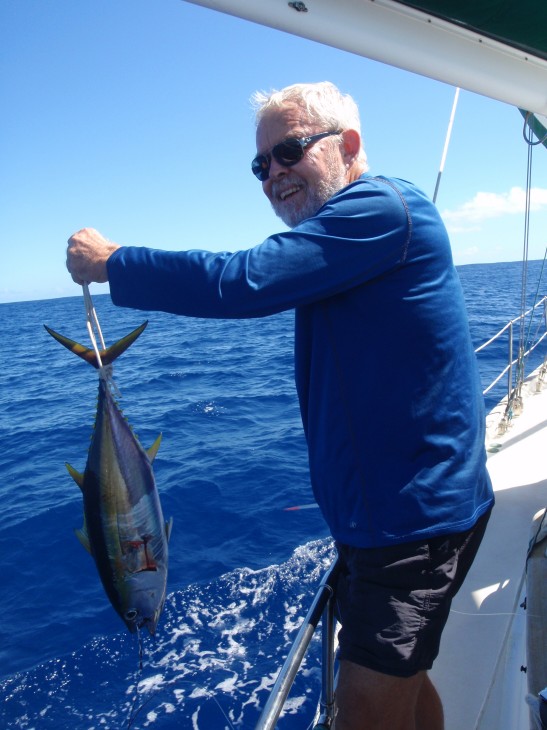
Caught this one between Raiatea and Bora Bora
We had a nice sail to Bora Bora. Our winds ranged between 3 and 14 knots, and we were able to sail most of the way. The seas grew as we headed west, and they were large when we were closing on Bora Bora. We caught a nice yellowfin tuna about six miles of Raiatea, and it kept us fed for a few days.
Bora Bora is approximately 170 miles from Tahiti. It is the oldest of the Society Islands – about seven million years old. It is at a stage between a high island like Tahiti or Raiatea – two to three million years old – and an atoll like the Tuamotus – ten to forty million years old.
The main island is 5.5 miles long and 2.5 miles wide. Its highest points are Mt. Otemanu at 2,385’ and Mt. Pahia at 2,169’.
It is surrounded by a lagoon that is three times larger than the land mass. There is only one pass in to the lagoon – Te Ava Nui – on the western side. The lagoon is rich in wildlife with more than 700 species of fish. There are many rays including manta, gray, and leopard. And there are gray sharks near the entrance.
Bora Bora was first settled around the 9th century. It was called Vavau or Mai Te Pora which means ‘risen from darkness’ or ‘created by the gods’. Its name became Pora, then Pora Pora, then Bora Bora.
Bora Bora has an interesting history from World War II. After Pearl Harbor was bombed in 1941, the US Navy sent a fleet of nine ships from Charleston, South Carolina to Bora Bora that included 4,450 troops and 178 officers. They arrived February 17, 1942. Called “Bob Cat”, this operation built water tanks and canons on the hillsides. They established fuel tanks and built a landing strip on Motu Mute. That strip on Motu Mute remains Bora Bora’s airport today.
Today Bora Bora is populated by approximately 6,000, and tourism is its primary source of income. Some historical marae remain and can be visited, but most were destroyed by the Christian missionaries. The main tourist draw is the beaches and lagoon. The tourism center is on the south end of the main island and includes many hotels.
The main village is Vaitape which is on the west coast of the main island directly inside the pass. We had planned to anchor or moor near Vaitape, but we were not able to find an available mooring. It is too deep to anchor near town, and the moorings are all privately owned. We crossed the lagoon and went south a ways to Bloody Mary’s restaurant. They have moorings that are available to guests, so we took one and treated ourselves to a drink and dinner at Bloody Mary’s.
The next day we moved to the lagoon between Motu Toopua and the outer reef and anchored in 17′. This is a stunningly beautiful anchorage. The countless shades of blue water against the heavily forested motu and just in front of the peaks of Mts. Otemanu and Pahia. This is why Bora Bora has a reputation for being beautiful. We explored in the dinghy, but the winds increased during the night, and this became a rough anchorage. We were not comfortable here, so we moved to the moorings at the Bora Bora Yacht Club.
We went to lunch once at the yacht club, and it was expensive and lousy. We shopped in the limited groceries in town, and we checked out with the officials. We had the equivalent of $3,000 USD on deposit as a bond, and it became a bit complicated to redeem it (multiple mistakes by customs), but we got it done. And we busied ourselves getting ready to sail home. We watched the weather carefully, and we determined that May 28 would be the day to leave. We were really looking forward to getting home.
Many colors of water off Bora Bora
Return to our French Polynesia page or sail with us from French Polynesia to Hawaii