PANAMA CANAL
The idea of the canal dates back to 1534 when the King of Spain sought a way to get riches from Peru to Spain. An overland route was was established in the late 17th century, but it was abandoned only two years later. Gold was discovered in California in 1849 and provided further motivation for a trade route between the Pacific and Atlantic. In response, the Panama Railway was built across the isthmus with a loss of more than 10,000 lives. But a canal seemed the obvious solution, and both American and French engineers proposed designs and routes.
In 1879, Colombia (Panama was then a part of Colombia) granted the right to build the canal to the French Societe Civile. Count Ferdinand de Lesseps, who oversaw the building of the Suez Canal, headed the project. Work began in 1880 on a sea level canal – one without locks. The canal was to be operational by 1892. Disease and the harsh geography and climate led to the project’s financial ruin by 1889 after spending the equivalent of $285 million USD and losing 20,000 lives.
In 1894, another French company resumed work on the canal at a slower pace. This company’s engineers recommended a lock type canal rather than the sea level canal previously proposed. But this company lacked the funding to proceed with the project, and they sold all ownership, rights, and equipment to the US.
In 1903, the US agreed to support Panama’s independence from Colombia in exchange for sovereignty over the ‘canal zone’. The project was enormous – more so than any previous construction project – and there was no existing infrastructure other than the railroad. They also faced issues of disease and land slides. But the canal was opened ten years later after spending the labor of more than 75,000 workers and the equivalent of $400 million USD. The first ship transited the canal on August 15, 1914.
As mentioned on our Panama page, David McCullough has written an excellent history of the canal – “The Path Between the Seas”. This book is highly recommended for anyone wanting to learn the history of this amazing endeavor.
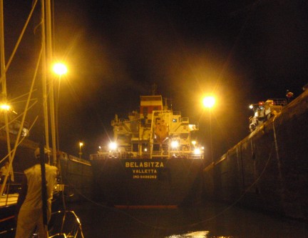
Inside Gatun Locks
Coming from the Caribbean, you travel 5.4 miles from the breakwater to the first locks – the Gatun Locks. These are three locks close together that raise you 85 feet, and you exit in to Gatun Lake. Gatun Lake is 23.5 miles long and 117 square miles. It was formed by damming the Chagres River.At the time of construction, The Chagres River Dam was the largest earthen dam ever built, and Gatun Lake was the largest manmade lake ever built. After crossing Gatun Lake, you enter the Gaillard Cut. This is a narrow channel cut through 8 miles of rock. This was originally called the Culebra (Snake) Cut because of its winding path. But it was later renamed the Gaillard Cut after Col. David DuBose Gaillard who oversaw its construction. This area was plagued with frequent landslides during construction and even after opening. At the end of the Gaillard Cut is the Pedro Miguel Lock. This locks lowers you 31 feet in to Miraflores Lake. This small artificial lake separates the Pedro Miguel Lock from the Miraflores Locks. These two locks are only one mile in length, and they lower you the final 54 feet to sea level on the Pacific side. The gates at the exit to the Pacific are the highest of all because of the large tides there.
A new set of locks has been under construction since 2007, and they are scheduled for completion in 2015. They are 1,400 feet long, 180 feet wide, and 60 feet deep. These locks will enable much larger ships to transit the canal. Their projected cost is $5.25 billion.
The canal zone includes the ports on either end of the canal. Port Cristobal is on the Caribbean end, and Port Balboa is on the Pacific end. Having arrived from the Caribbean, we entered the canal zone at Port Cristobal.
On May 8, we sailed through the breakwater to the Caribbean side of the canal zone. – Port Cristobal We went to Shelter Bay Marina, which is inside the breakwater, to prepare for our canal transit.
Shelter Bay Marina is a good place to arrange a canal transit. They are familiar with the procedures, and they are tolerant of the ambiguities in scheduling.
The marina is built at the site of the former Fort Sherman – a US Army base. Fort Sherman was the primary defensive base for the Atlantic sector of the canal. It was also the site of the Jungle Operations Training Center (a little insight in to the local environment and climate). The fort’s 23,100 acres were turned over to Panama when the canal was – December 31, 1999. The base has since been abandoned, but the base’s dock has been expanded in to Shelter Bay Marina.
We had previously made e-mail contact with a recommended agent, Roy Bravo of Emmanuel Agencies, and we met on board Passage a few days after our arrival. He patiently walked us through the process. We jumped the sequential hoops, and we found the process a real pain in the ass, but the canal authorities feel the same way about sailboats. They make big money off the big ships, but they don’t make so much off sailboats. They tolerate us, but we are very low on their priority list. (It is nearly impossible to get them to even respond to radio calls.)
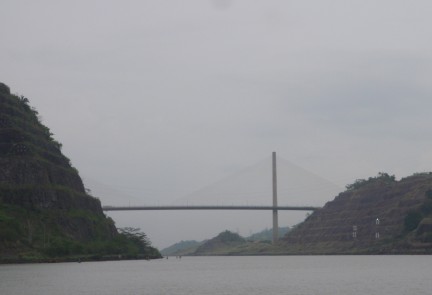
In Culebra Cut – approaching Centennial Bridge
Canal tolls are a substantial source of income in Panama. The average toll is approximately $54,000. The highest toll paid so far was $375,600 by the Norwegian Pearl cruise ship. And high fees are paid for priority passage with one ship having paid $220,300 in addition to their regular toll. Our canal fee was $800, so we were very low priority. (We did not get through the canal for only $800. Other fees brought the cost to $2,200 total. But the canal fee was $800.)
At this time, all east-to-west sailboats (like us) are scheduled for two day transits. On our first day, May 15, we were scheduled to go only as far as Gatun Lake where we would spend the night. On the 16th, we would go all the way to Balboa.
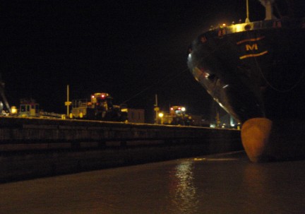
Pulling in front of ship in Pedro Miguel lock
Our actual transit of the canal began the afternoon of May 15 after another schedule change – a recurring event. Our crew of linehandlers was Rico, Norberto, and Ray. They boarded in the marina, and we motored out to the anchorage where we were to pick up our pilot.
We were one of three sailboats transiting together. There was the very large SV Bliss – a 120’ monster – and a small catamaran. Bliss took the center position, we rafted to her starboard side, and the catamaran rafted to her port side. Bliss took lines to each side of the lock, and we were tied only to her. Bliss did all the motoring and maneuvering, and we were essentially parasites.
Ships are ‘dragged’ through using railroad cars, but they also use their props for some propulsion as they enter and leave the locks. Sailboats (even 120’ ones) use only their own propulsion, and men walk the walls of the canal holding lines but providing no forward movement.
The sun had set by the time we entered the first of the three Gatun Locks. We had a large ship ahead of us and no others behind us. We filled the 1,050’ length of the locks. The gates closed behind us, and the lock began to fill (we were locking up). The turbulence was not near as bad as we had feared. Then the gate opened ahead of the ship, and we went to the second lock then the third lock. The worst turbulence we experienced was from the ship’s propeller, and it was not a problem.
The skies opened while in the third Gatun Lock, and it poured rain. We should have done this about two weeks earlier.
When we exited the third Gatun Lock, we had been lifted 85’, and we were in Gatun Lake. We motored to a mooring buoy and tied up. The small catamaran rafted up to us for the night. It was pouring rain.
Our pilot was taken ashore by a launch, and the three linehandlers stayed on board. We had a late dinner then found places for the guys to sleep.
Our second pilot was scheduled to board at 0600 the next morning. We got up early so that we could have coffee, juice, and muffins before getting underway. We could make a bigger breakfast while crossing Gatun Lake. No pilot. We finally got a message that he would not arrive until 1000. He arrived shortly after 1300.
We crossed Gatun Lake and thoroughly enjoyed the jungle scenery. There are many ‘islands’ that remain above the flood level. There are also tops of some dead trees outside the channel. And the jungle is very dense. Most of the lake is around 60 feet deep. The lake front is not inhabited other than a Smithsonian Institute research station that studies tropical animals and plants. There is a lot of dredging being done for the new channel and locks.
We entered Gaillard Cut which is an eight mile stretch blasted through rock. Rock slides still occur in this area, and there is an ongoing effort to contain the loose rock walls. The most recent rock slide was just last year.
We arrived at Pedro Miguel Lock about 45 minutes ahead of schedule, then we waited more than two hours. When Bliss and the catamaran arrived, we rafted up in the same configuration as the previous day – Bliss in the center with us on her starboard side and the little catamaran on her port side.
When locking down, the sailboats enter ahead of the big ships, so we had a better view this day. Unfortunately, the sun had set while we were waiting to enter Pedro Miguel Lock. There is so much there that would make great photos, but not at night.
The movement during locking down is barely perceptible. There is no turbulence. It feels as though you are staying in place and the walls are rising around you. We exited Pedro Miguel Lock 31 feet lower than we entered.
We stayed rafted with Bliss and the catamaran as we motored the one mile across Miraflores Lake. Actually, Bliss motored and carried along her two parasites.

Last Miraflores lock opening to the Pacific Ocean
We entered the first of two Miraflores Locks to lock down the final 54 feet to the Pacific. It was another quiet decrease in altitude in the first lock. Then we entered the final lock – the last gate between us and the Pacific.
There was a very strong current running through the final lock toward the final gate. We estimated it to be at least 4 knots. We don’t know if we could have stopped Passage if we were not tied to Bliss. Our lead linehandler told us that boats our size often end up sideways in that lock. This is where some have hit the wall. We were very happy to be secured to Bliss. We never did get a good explanation for that ripping current.
The final gate opened, we released our lines to Bliss, and we motored out in to the Pacific Ocean. Passage has not been in the Pacific since we arrived in Australia in November of 2006 – seven and a half years ago. We were very happy to be back.
We motored about three and a half miles to where we dropped off our pilot. We had requested a mooring at Balboa Yacht Club, and it was almost 11:00 PM local time when we arrived. Our linehandlers stayed on board until we got secured there, then a launch took them ashore.
We sat – a bit numb. This had been more of an experience than we had expected. We were frustrated by the frequent and long delays, and we were not happy with one of our crew. But the canal was awesome. We were amazed by so many aspects of the canal – its engineering, its history, it physical structure, its beauty, its value. Quite an experience!
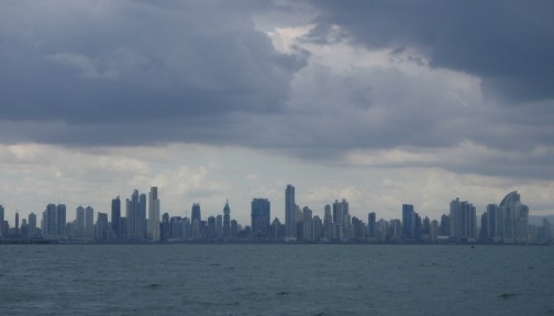
Panama City skyline
Our mooring at Balboa Yacht took some getting used to. We were only about 100 feet outside the channel leading to the canal, and the flow of ships in both directions is non-stop. It is a bit unnerving to look outside a port and see one of these behemoths so close! At sea, anything less than one mile off is too close.
Surprisingly the ships did not create much of a wake, but the tugs and work boats did. We had heard that these wakes make this a particularly uncomfortable place to stay, and we agree. There are two marinas in Panama City, but it is nearly impossible to get a slip at either, so we stayed at our bouncy mooring at Balboa Yacht Club for three nights.
We knew that this would be our last place to top up fuel and provisions and do laundry before heading offshore, so we got busy. Three wet linehandlers left us with lots of dirty wet laundry and lowered our food stores.
Laundry was easy. Food was slightly less successful. We went to a large grocery, but we were disappointed in their fresh produce. When will we next find any? And fuel became a challenge.
The fuel dock at Balboa Yacht Club was just too rough. We did not want to take Passage in there. We called La Playita Marina, but they could not get us in that day at any time. But Flamenco Marina was welcoming, so we headed there for fuel.
After fueling we dropped our anchor at Las Brisas anchorage – just offshore from Panama City. We had read that this was a big city, but we were surprised by what we found. It is a real big city! And it was a very pretty skyline at night.
We had fuel, food, and clean laundry. It was time to put the canal experience behind us and move on. We left Panama City in the morning on May 20 headed for Panama’s Las Perlas Islands.
Return to our Panama page
or our San Blas Islands page
or our Costa Arriba page
Follow us to the Las Perlas Islands.
Or come along as we are back in the Pacific again.