NORTHERN INDONESIA TOWARD SINGAPORE
We guestimated this passage to be a bit over 500 miles, and we debated doing it in day sails, a series of overnighters, or one long haul. There are so many islands in Indonesia that one would think there would be ample opportunities to stop to sleep for the night, but it is not so. In northern Indonesia, islands with anchorages are few and far between (literally). So we decided to do one three- to four-day passage, then we could finish our way north with day sails.
Our sail from Kumai was four-days-three-nights. We traveled only 428 miles during that time. We motorsailed almost the entire distance, and we had countercurrent much of the way – often as much as 2 knots. Our weather was squally, and it seemed that the only time we got enough wind to sail was with a squall. We had a bit of commercial and fishing traffic crossing the Karimata Strait, but we never saw another sailboat. Fish slayer caught two nice Spanish mackerels in the morning of our last day out.
We made landfall at Cebia Island in the Tuju group. Cebia is a small island, and it appears that a few people live there. To describe Cebia as beautiful would not do it justice. This is what you see on picture postcards. Surely its remoteness is the only reason it has not yet been developed in any way. We spent a quiet night on Cebia and slept very well.
The following morning we left at sunrise. We sailed 61 miles north to Lingga Island. Although we motored most of the day, we did get to sail for a few hours. (Rather than dodging squalls, we were seeking them out. That is the only time we get to sail!)
We were surprised to find two Aussie boats anchored at Lingga. They invited us ashore for an evening around a bonfire, but we declined. We opted to cook/eat some of our fish and catch up a bit more on our sleep. At dark, when we turned on a few lights, we were swarmed with small flying bugs. They were neither mosquitoes (Nita was relieved) nor termites (Bud was relieved), but they were numerous and annoying. So we turned out the lights and went to bed at 7:00 pm.
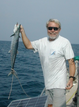
One of two spanish mackerels
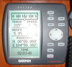
Crossing the equator again
The following day we sailed 53 miles to Mesanak Island. It started raining shortly after we left, and it continued to rain most of the day. We saw one small waterspout form close behind us, but it dissipated. The big event of this sail was that we crossed the equator again – this time headed north. We last crossed the equator on June 1, 2005 at 158.03W. That was 2 years 4 months and 2 days prior. Today we crossed at 104.50E. That is 1,549 miles west as the crow flies, but we have actually sailed 11,449 miles since then.
We went to sleep early, and we were up before dawn and headed further north. We were running a bit low on fuel, and we wanted to take on some more before crossing the Singapore Strait (not a place to run out of fuel!), so we decided to head northwest where we believed we could get fuel and get a bit closer to where we wanted to cross the strait. We actually got to sail for a while, but we also motored for a few hours through moderate rain.
We arrived at Pulau Boyan – our fuel stop – in the early afternoon, and nothing seemed to go as planned. We had to tie up to a barge with more than 1 ½ knots of countercurrent, and Nita fumbled the stern line. Suddenly we were waving around in the current. We recovered from that, and we discovered that the fuel would need to be pumped via a very large diameter hose in to our very small diameter fuel fill. Consequently we were not able to filter this marginal looking fuel. But they started the pump, and diesel went everywhere. Bud was covered up to his knees, the aft half of our port deck was awash, and diesel was spilling in to the water. We decided to take on only a small amount – just enough that we could be confident that we would make it to Singapore. After the first round of clean up, our garbage bag wreaked of diesel, so Nita asked if they could take the bag for us. They indicated we should dump it in the water! Needless to say, we did not. However, we were disappointed to learn how the locals are disposing of their waste – including fuel contaminated waste.
We got off the dock a bit more gracefully than we arrived, and we headed further north in search of an anchorage for the night. We are still somewhat in the southeast monsoon, so we wanted a sandy place on the northwest side of any convenient island. The first one Nita (the nagrivator) found – Pulau Kepel Besar- was about 8 miles further up the channel – 64 miles from where we spent the prior night. We decided to go there. As we neared we realized that this was on the southern aspect of the main Singapore Strait. But it was out of the strait, so we dropped our hook and spent the evening watching the strait traffic from our cockpit.
Our course since Kumai had deviated from the rhumbline so that we could stop to sleep most nights. In the end, we traveled 606 miles from Kumai to Pulau Kepel Besar. Most of the islands and waters we saw along the way were quite beautiful, and we found ourselves wishing we had spent more time in northern Indonesia. But it was time to look forward, not backward.

Our fuel barge and crew
We were both a bit anxious about crossing Singapore Strait the next morning, so we spent a few hours reviewing charts and sailing directions for the umpteenth time. We were as ready as we would get. So we spent our last night in Indonesia with gratitude for all that the Indonesians have shared us and a bit of sadness at leaving. But Singapore was calling.
Come along as we cross the Singapore Strait or jump ahead to Singapore.