BALEARIC ISLANDS
The Balearic Islands, or Islas Baleares in Spanish, consist of four main islands – Mallorca, Menorca, Ibiza, and Formentera – and many smaller islets. The islands are under Spanish sovereignty.
The westernmost islands are less than 50 miles east of the Spanish mainland. They are low-lying with sandy bays. The islands run to the northeast and become higher in elevation and rocky. Most of the islands have highly indented shorelines with numerous calas – coves – for swimming or boating.
We arrived in the Balearics at Porto Colom on Mallorca.
Mallorca is the largest of the Balearic Islands. It is 62 miles long and 47 miles wide. The north and east coasts are mountainous with numerous coves, and the south coast has rolling hills and sandy beaches. The central plain is flat with large areas of fertile agricultural terrain.
Mallorca has been inhabited for at least 6,000 years. Archeological evidence suggests that the inhabitants included the Phoenicians, Carthaginians, and Greeks. The Romans conquered Mallorca in 123 BC and remained until the 5th century AD. After the decline of the Roman Empire, the Vandals invaded and used the island as a base for pirates and Corsairs. Mallorca has one large port – Palma.
The Moors arrived in the 10th century and brought prosperity with the development of Palma. Irrigation and agriculture was improved across the island. However, King Jaime I drove the Moors out in 1229. That is when the Catalan language was introduced – the primary language throughout the Balearics.
The 13th to 15th centuries were a time of great growth on Mallorca, but Spain turned her attention to the New World and somewhat forgot about her Mediterranean possessions. Mallorca experienced frequent pirate attacks, but gradual growth continued.
Today Mallorca’s coastline is overrun with tourism and its infrastructure. One must look hard to see past it.
We had a somewhat chaotic landfall at Porto Colom. The winds were increasing, the seas were bumpy, and we had a narrow entrance channel ahead of us. As we approached, we saw a power boat come out, make a few circles, and go back in. Then he came out again. His driving was a bit erratic, and it made it difficult for us to plan a course in to the port. But we got around him and in the entrance channel. Then we had four kayaks to contend with. There was one adult and three children in the kayaks, and none were wearing PFDs. The winds were too much for one of the kids, and he was out of control. The other kayaks were trying to help him, but they were scattered about the channel – in front of us no matter which way we turned. We still had 20 knots of wind blowing us down. But we dodged those obstacles as well, and the power boat passed us as he returned to port again. We hoped that this was not telling of experiences to come.
Shore in Porto Petrol anchorage
We had already decided that we would pick up a mooring in Porto Colom, but it was a bit more difficult than we had anticipated. There are no pennants on the moorings, so one has to get their line through the loop on top of the ball. This, too, got a bit messy (Nita was bruised and Bud was bleeding before we were secured), but we got it done. Later in the day, we saw that an employee of the marina comes out and helps boats, but we were too early in the morning. Our mooring cost us 33 Euros – the equivalent of $41.25 per night.
We chose to make landfall at Porto Colom because we thought we could find a Vodafone store there to get our telephone activated and internet service established. Wrong. The nearest Vodafone store is in Felanitx about eight miles inland, so we hired a taxi. The drive was pretty. We passed through agricultural lands to a depressed appearing town. The Vodafone store had a SIM card for our phone but not for the internet. We would have to go to another store at a substantial distance to get it. We gave up.
We returned to Porto Colom and did a bit of food shopping at a pleasant little market a block up from the coast. The people were friendly and helpful. We walked around town a bit and scouted out the fueling situation. We decided we were too tired to enjoy a meal out, so we returned to the boat.
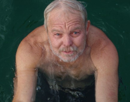
A chilly swim at Porto Petrol
We did not know if/when we would find fuel again before Gibralter, so we decided to top up our tanks before leaving Porto Colom. We took on 76 gallons at the equivalent of $6.76 USD per gallon. That is the least we have paid for diesel in some time.
One of the first things we noticed as we traveled down the coast is the clean air. This is the cleanest air we have seen since we have been in the Med. A very refreshing change!
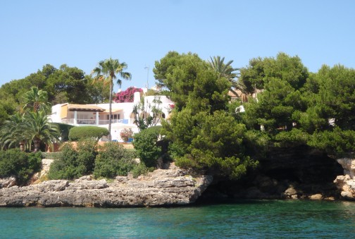
Mallorca’s southeast coast is highly convoluted, and there are calas all along it that offer anchorage to boats. We traveled 7 miles in the next 1 ½ hours, and we looked in to twelve calas, but we could not find a place to anchor. We looked at Calas 1) Mitjana, 2) Serena, 3) Ferrera, 4) Esmeralda, 5) Gran, 6) d’Or, 7) d’es Pous, 8) de sa Galera, 9) d’Egos, 10) del Llamp, 11) se sa Torre, and 12) d’els Homos Morts. Each was either already overcrowded with boats or it had been roped off for swimming. We had been cautioned that the crowding here would be a problem, but we really were not prepared for the masses of boats and bodies that we found.
So we went in to Porto Petro (which ironically does not sell fuel), and we picked up a mooring in Cala del Mats (our 13th cala of the day). These moorings are managed by a local marina (Reial Club Nautic Portopetro), and it cost the equivalent of $31.25 per day.
The cala itself is pretty. It is rocky with a few caves. There are beautiful, but not overly ostentatious, homes built along the shore. There are about twenty moorings installed in the cala.
The town was less appealing. It is very touristy. We did not see much local color. And we had a lousy introduction to Spanish food in Porto Petro. We had a mixed tapa plate and seafood paella at one of the overpriced waterfront restaurants, and both were quite poor. We will have to try again elsewhere. We decided we needed a boat chore day before moving on, so we took it. Then some weather blew in, and we took a weather day. The weather lingered, and we ended up staying four nights. Our last night was very rolly, so we were determined to get out of there at the earliest opportunity. We left the next day headed for the southeast corner of the island.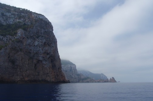
Beautiful northwest coast of Ibiza
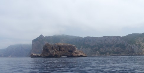
More of Ibiza’s northwest coast
We found the young party crowd in town in Puerto de San Antonio. From what we heard, it seems most of these revelers are English. There are numerous discos where just the cost of admission is between $75 and $100 per person, and we have no idea what they might charge for a drink once inside. Not a lot of clothing is worn, and body and face painting is very popular. And much of it was surprisingly well done! Lots of drinking. And we saw a few carnival-type rides with the most outrageous one being a sling-shot – like a reverse bungy jump. The intrepid sit in a seat while elastic bands are stretched upward. When the seat is released, it shoots skyward and bounces up and down a few times. No, we did not do it.
We did find a Vodafone shop in town. We got a SIM card and had internet access again. We had access to weather information again, and we were able to make our plans to move on.
We wanted to repair our steaming light on the mast, and it turned in to an all-day project that required a few trips to the chandlery in town. As we returned to the boat in the late afternoon, we saw that our anchor had dragged. This is our first time ever! Passage was well below where she had been, and she was dangerously close to the boat behind us. Fortunately, the owner of that boat was an experienced boater, and he knew how to manage the situation until we returned. We quickly got the anchor reset, apologized profusely, and thanked our neighbor for his quick actions. We think we know what happened, but we will never be sure. Don’t want that to happen again!
The anchorage had become quite crowded, but it was late in the day. We decided to stay a second night before heading to the next island of Formentera.
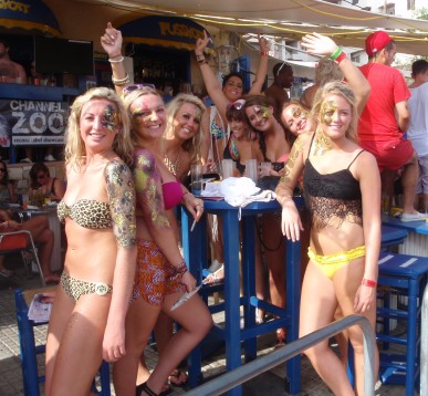
They would still be gorgeous without the body paint
We arrived in the north on Espalmador. There were boats as far as we could see. Hundreds? More? There were dinghys and jet skis racing around the anchorage creating wakes in all directions. This was not looking good. We thought we would go further south and find a quieter anchorage.
We continued south and found a continuous mass of boats. There must have been at least 1,000 of them. But after passing the harbor on Formentera, there were only a few boats in a large anchorage. We dropped our anchor, and within a minute or two, a large dinghy approached and told us that this area was part of a local seagrass project and anchoring was prohibited. Because of language issues, we did not learn why a few other boats were anchored there. We headed back to the masses on Formentera.
We anchored in the best spot we could find, and we watched with incredulity as idiots raced around endangering themselves and others. And our plan was to spend four nights there before heading to Gibralter! We needed to rethink that plan.
The early hours of the night were quite rolly, but it calmed by morning. The roll was just from the boats and jet skis racing around. It settled a few hours after they stopped.
We went to the small town on Formentera the next day, and we found nothing of any interest at all. It was a mass of tourists getting on boats to go out for day cruises. We wanted out of there.
Our plan had been to sail directly from Formentera to Gibralter, but we changed it to go to the mainland of Spain. From the mainland, we could either coast hop our way down or do it in one run. But it would get us out of Formentera. So we spent a second night – again very rolly in the early hours – and left before dawn for mainland Spain.
Follow us to mainland Spain