SAILING IN GREECE
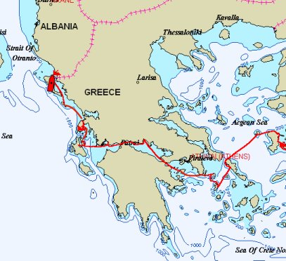
As we already said on another page, we have visited the mainland and all island groups other than the Sporades and Crete. We will describe our experiences chronologically and by island group.
Our first trip to Greece was to Rhodes which is one of the Dodecanese islands. Historically, Rhodes’ distance from Athens has enabled numerous invasions of these islands, and the architecture reflects the various occupiers – particularly the Ottomans and Italians. These islands were the last to be incorporated in to modern Greece in 1948.
Today the Dodecanese islands are known for their nice beaches and hot weather. Consequently, they are also popular tourist islands.
Our first trip in to Greece was not on Passage but by ferry. We were in Turkey, and Nita’s visa was about to expire. Immigration law at that time (now changed) required one to just leave the country – regardless of duration – and return to get a new visa. It was a short ferry ride across the channel, so off we went for a day trip.
Rhodes was an important island during the 5th to 3rd centuries BC. It was the site of one of the Seven Wonders of the World – the Colossus of Rhodes. The Colossus was a 105 – 130 foot bronze statue of Helios, the sun god, built in 305 BC to celebrate Rhodes victory over Demetrius of Macedonia. Drawings of the Colossus often depict it straddling Mandraki harbor; however, it more likely stood at the Temple of Apollo which became the site of the Palace of the Grand Masters. The Colossus was toppled by an earthquake in 227 BC.
Rhodes was part of the Roman then Byzantine empires, then it was conquered by the Knights of St. John in 1306. These crusaders built a walled city that still stands, and they occupied Rhodes until 1522. Ottoman and Italian rules followed. Today Rhodes is a popular tourist island.
We arrived in Mandraki Harbor which is at the northern tip of the island. From the harbor, it is easy to walk to both the old town and the new town.
Old town has been inhabited since the 5th century BC. The Knights of St. John built their citadel over the existing development when they arrived in the early 14th century AD. Old town is surrounded by moats and a city wall that is 2 ½ miles long and up to 40 feet thick. There are eleven gates through the wall, and the Palace of the Grand Masters is the center of the old town. There are numerous buildings from the 14th and 15th centuries as well as the Mosque of Suleiman the Magnificent which was built in the 16th century to commemorate Suleiman’s conquest of Rhodes.
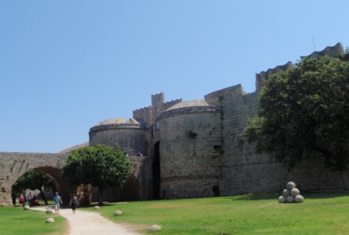
Palace of the Grand Masters – Rhodes
New town is attractive but far less interesting than old town. New town includes the harbor, the marketplace, and a large park. The government house, previously the Italian Governor’s Palace, is also in new town.
We had only one day to explore, so we stayed in Rhodes town and focused on old town. We spent much of the day walking the perimeter of the castle and exploring the various gates.
We finally left Turkey and entered Greece with a vague itinerary. But we knew our first destination: the north Aegean Island group.
The northern Aegean islands share much common history of rule by the Genoese and a history of fishing, but they have developed quite distinct from each other. We visited Chios and Psara which seemed quite different. However, what they have in common is that neither are tourist islands.
Chios is 27 miles long and ranges from 7 to 16 miles wide. It has a mountain range running north to south.
Chios was probably a relatively affluent island in ancient times when it was part of the Ionic Confederacy with Samos and Smyrna. It was subsequently sacked by the Romans then became a pirate stronghold until the Genoese Giustianni family gained control in the 14th century and affluence returned.
The Turks took and occupied the island in 1566. When the Chians joined the Greek War of Independence, the Turks razed much of the island in 1822. Approximately 30,000 were killed and twice that many were enslaved. Although the mastic villages were not attacked, no other area was spared – including monasteries. Chios was still recovering from the massacre when it was devastated by an earthquake in 1881. Yet the island recovered. And the one industry not attacked – the mastic industry – continues. Twenty villages on the southern part of the island cultivate the mastic bush for its resin. However, in Chios town, almost all buildings have been built since 1881.
There is a port in Chios town, and sailboats have anchored there in the past. However, it has a reputation for being dirty, noisy, and very bumpy at times. So we chose to go to the Chios Marina.
Development of this marina started many years ago, and it stopped after the concrete was poured. It has silted up to only about three meters of depth, and there are no facilities whatsoever there. But it is a quiet and safe place to tie up. The walk to town is about one mile.
Checking in to Greece was an introduction to Greek life – they live very loud – but it went without incident. Our first task was to get a telephone and internet connection. The phone was easy; the internet was not.
We walked around town and had an overpriced lunch on the waterfront. Almost all businesses close from 1400 until 1800, so we essentially killed time until the telephone/internet store reopened.
We explored the main harbor and found it filthy and disgusting. Raw sewage is dumped in to the harbor right in the center of town. We are glad to be at the ‘marina’ – even if it is a ways out of town. And at the end of the day, we got back to the boat at 2030, and we still did not have internet.
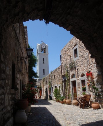
Mastic village of Mesta
We rented a car for two days so we could see other parts of the island. Our first day was spent visiting the mastic villages on the southern part of the island.
The mastic bush continues to be an economic mainstay for much of this part of the island. This bush secretes a resin that was used as the basis of paints, cosmetics, and medicines prior to the advent of petroleum-based products. Today, mastic resin is used mainly as a flavor in foods and the liqueur, mastika (Nita believes the worst tasting liqueur she has ever tasted). But the villages are unique and worth a visit.
There are 20 mastic villages in southern Chios. These villages were founded in the 14th and 15th century by Genoese overlords. Each village is designed for defense and built in a similar manner with the town center literally in the center of the village. There are fortification towers at each corner and an outer wall of houses. The houses are of the same height with flat roofs to enable escape if necessary. The streets are narrow passageways intended to confuse strangers (we got lost twice), and there are flying buttresses to help support the structures during earthquakes. For reasons unknown to us, the mastic villages were the only part of Chios not attacked by the Ottomans during the massacre of 1822.
We visited three villages and drove by or through three others. Our favorite, by far, was Mesta. This is the best preserved of the villages. It still has the corner towers and perimeter houses. Most of the roofs remain the same height; however, most now have solar water tanks, satellite dishes, etc. The church in the center of the village is beautiful. Unfortunately, they ask that no pictures be taken inside the church. There are a few small tavernas at which one can get food or drink (Bud got ice cream) and watch village life.
The drive to and from the villages was also time well spent. The roads are in good repair, and the scenery is very nice. This is a recommended outing for anyone traveling to Chios.
Our second day of tourist outings was a visit to the Nea Moni Monastery. This is in the mountains less than an hour’s drive from Chios town.
The monastery of Nea Moni was built in the mid-eleventh century by the Byzantine emperor Constantine IX Monomahos. It functioned as an influential monastery after the fall of the Byzantine Empire, and at one time it owned nearly one third of the land on Chios and 800 monks belonged to it. The power of the monastery lessened during the Ottoman Empire, but it remained substantial until the massacre of 1822. Many Chians fled to Nea Moni for safety, but they and 600 monks were killed. The monastery was further damaged by the earthquake in 1881.
Nea Moni has been a convent since 1952. However, it will revert to being a monastery again when the last nun there dies.
When one arrives at Nea Moni, the first building inside the gate is a small chapel. This chapel contains a cabinet containing the skulls and some bones of some of those massacred there in 1822. But only a few steps further is the spectacular church.
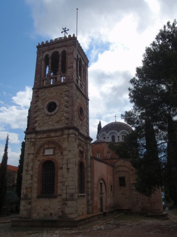
Nea Moni Monastery/Convent – Chios
There is an attractive belfry that is a relatively modern structure added after the 1881 earthquake. The rest of the church is constructed from stone and marble. Attached to the belfry is an entry area. Next to the entry area is the narthex with beautiful mosaics. Twenty eight saints are depicted and the Virgin and Child are on the central dome. The main apse is connected to the narthex, and it is decorated with mosaics.
A thunderstorm blew over us while in the church, and we spent time just sitting in the dark narthex looking at the mosaics and taking in the atmosphere. It was a somewhat surreal place to sit out a thunderstorm.
When the clouds passed, we walked around the grounds. The outbuildings are in various stages of disrepair, and we enjoyed the views of the valley below
We left Chios ‘Marina’ and traveled 14 miles in 3 hours. We were headed toward the north end of the island. We found a small bay, Ormos Parapanta, just west of the northeast corner of the island. We had it to ourselves.
A few hours after anchoring we heard bells. There were many of them, and they all seemed to sound different. They grew louder. Then the goat herd started emerging from the brush. There were hundreds of goats – maybe 500 – and almost all of them wore a bell around their neck. It was a cacophony of bells. They slowly wandered by on the shore, and their music disappeared over the hills. It is not often that a herd of goats can produce a magic moment, but this herd produced a magical half hour.
That night the winds and seas built, and our peaceful anchorage became uncomfortable. By the next morning, we were about one boat length from a lee shore with choppy seas and winds in the 20s. We rode it out and looked forward to moving on.
The winds and seas were very calm the next morning. We took advantage of the break in the weather and motorsailed 29 miles in 6 hours to Psara Island.
Psara is a small island that was nearly wiped out during Greece’s War of Independence. Ottoman forces did not land there until June, 1824; however, almost the entire population was killed. A few survivors remained on the island, but it never recovered.
We side-tied to the quay in Psara’s only harbor. Men were sitting watching us, but no one offered to help. That was a recurring feeling on Psara. The people seemed most unfriendly. Not hostile – just unfriendly. We walked around the town, and no one made any eye contact nor spoke to us. We had dinner onboard, and we spent only one night. We left at sunrise the next morning.
Cyclades is derived from “kyklos” which means circle. The Cyclades surround the previously sacred island of Delos.
The Cyclades are the home of the Cycladic civilization which developed in the Bronze Age and produced spectacular art. Subsequently, the Minoans from Crete colonized the islands and developed Santorini as a major trading center. Then the Mycenaeans took over the islands and developed Delos as their religious capital. Centuries later, the Venetians ruled the islands, and their influence can still be seen. Today, the Cyclades are the most visited group of Greek islands.
We visited three of the Cyclades – Andros, Kythnos, and Kea. They were mostly rocky, barren, and dry with a few pleasant exceptions.
To get from Psara to Andros, boats must pass through the Kafireas Strait which is infamous for bad conditions. The forecast was for calm conditions, so we chose to take advantage of it and get through the strait.
The winds and seas were calm as predicted, so we had a long day of motorsailing – 75 miles in 13 hours. We went all the way to Andros Island.
Andros Island is the northernmost and second largest of the Cyclades group. It is a mountainous island and wooded in places. It is not as barren and dry as others of this group. It is popular with Greek tourists but not particularly popular with foreigners.
The main port on the west side of the island is Gavrion, but we were trying to find anchorages rather than ports. We went a bit further south to Batsi and checked it out, but it was a touristy port that we did not like at all. We went further south to an open bay – Palaioupoli – and found a sandy spot in 12’ of water.
This was one of the most beautiful anchorages we have been in. Beautiful old houses dotted a steep hillside amid scattered ruins. Pink bougainvillea grew wild on another hillside. We just sat and stared at it for a while trying to take it all in. Stunning scenery.
The next morning, we awoke to the pealing of church bells and wanted to stay another day or so. We knew, however, that this idyllic anchorage could get ugly if any weather blew over, so we left after only one night. But the beauty of that anchorage is a lasting memory for us.
We had been told that Kythnos was a particularly nice island by a few friends. Stefanos Bay had been specifically recommended, so we headed there. We traveled 32 miles in 6 hours.
Kythnos is a barren rocky island reportedly without much tourist traffic. However, as we approached the island, a few fast tourist boats passed us and appeared to be coming and going from Stefanos Bay. Sure enough. We arrived to find that the fast boats were based there. There were also a few cruising boats in the anchorage, but they are rarely a problem. But the fast boats quickly convinced us that this, too, would be a one-night anchorage.
We moved north to Kea traveling 28 miles in 5 hours. Kea is another mountainous island to the north of Kythnos. We had a wonderful sail across the strait between Kythnos and Kea.
Most of Kea’s population lives in the village part way up the hill. Only a small community lives around the harbor.
The main harbor of Kea is Port Nikilao. This is a ferry port with two small villages and a small anchorage. We went to the anchorage.
We went ashore and walked the waterfront. There were a few shops with very high prices for poor merchandise, a small grocery that lightened our wallets a bit, and a few tavernas. We decided to treat ourselves to a meal out.
A common fish here is sea bream. We like it ok, but it is not our favorite. But we thought we wanted a chunk of fish, so we looked at a few menus. The only restaurant where we saw sea bream charged the equivalent of $75 USD for a fish – not a meal. This is the same fish that we ate in Turkey for the equivalent of $7.50 for an entire meal. We did not have sea bream, and we did not eat at that restaurant. We found another restaurant nearby that was still a bit overpriced and just ok, but we satisfied our urge to have a meal out.
We wanted to keep moving. We stayed just one night in Port Nikolao.
We moved 16 miles in 3 hours to the mainland planning a few days in Athens before transiting the Corinth Canal and heading for the islands in the Ionian Sea. We headed for Cape Sounion which is the southern point of the mainland just 30 miles below Athens.
We started our short day motorsailing, but the winds quickly filled in. We had a glorious sail!
Sounion is notable for the temple ruins on the point. These ruins are of an ancient temple of Poseidon. The original temple was built around 700 BC, but it was destroyed in 480 BC. The second temple was built around 440 BC, and it is the remains of that temple that survive. These remains are columns atop a point jutting in to the Mediterranean, and they are a dramatic sight. They are lit at night and are even more dramatic.
We wanted to hike up to the ruins, so we planned to spend at least one night, hike the next day, then possibly spend a second night. Then the swell rolled in. It was so bad that we put out our flopper-stopper for the first time in a few years, and it was still miserable. It was still miserable in the morning, so we decided against our hike and left.
These islands are the closest group to Athens. Consequently, they have benefited from a rich history, but they are now somewhat overrun with tourists – foreign and domestic. We visited one of these islands – Aigina – rather than taking Passage in to Athens. Some of them seem to have become somewhat of a suburb.
We decided against taking Passage to Athens. We just didn’t want the hassle of the big city. Instead, we traveled 32 miles in 6 hours to Aigina Island from where we could take the ferry back and forth to Athens. The seas calmed about an hour out of Sounion, and our trip was uneventful other than dodging ships as we crossed the separation lanes.
Aigina is a small island – about five miles across and five miles long – just twelve miles southwest of Athen’s port of Piraeus. It has been inhabited for more than 4,000 years, and it was an important settlement until it was conquered by Athens in 456 BC.
Today it is a charming collection of villages that appeals to the Greek tourist more than the foreign tourist. It is also the site of some beautiful churches and the ruins of the Temple of Aphaia.
There is a port/marina on the northwest corner, and we headed there. We did not know who to contact to get a berth in the port, so we anchored out and took the dinghy ashore.
Finding the various offices was a challenge, but eventually the port police told us it was ok to come in to the port. We moved inside and tied stern-to a wall in front of a small café. Noisy but calm. We slept well.
The next day was dedicated to cleaning up – ourselves and the boat. Then we went ashore to find out how to get to Athens. We learned how to take the ferry from Aigina to Athens, and we planned to figure out the rest when we got there.
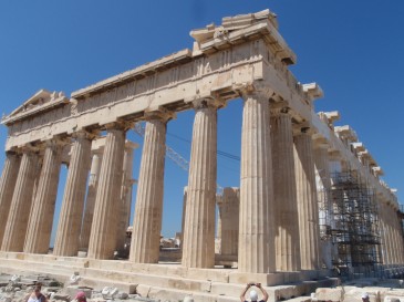
Parthenon
There are ‘slow’ ferries between Aigina and Athens that take 60 to 75 minutes, and there are ‘fast’ hydrofoils that take 40 to 45 minutes. Although we were not particularly concerned with going slow or fast, Bud wanted to experience the hydrofoil, so we took it to Athens. It was fast and fairly smooth, but it was also noisy and confining. Nita did not care for it. But we got to Athens without taking Passage there.
Athens is the capital of Greece. Although it has the usual characteristics of a capital city, it has a more interesting history than many. Part of their history can be seen at the Acropolis and the Archeological Museum – our two destinations in Athens.
Athens covers 176 square miles, and we did not know our way around, so we hired a taxi to take us to the Acropolis. This is probably the most visited tourist site in all of Greece, but our cabbie could not find it. Turns out she was new to driving a cab, but still…
For centuries, the sacred rock of the Acropolis was the most important religious center in Athens. It has been occupied since the Neolithic period. It was the seat of the king during Mycenaean times, and it became the home of the cult of Athena (namesake of Athens) around the 11th century BC. During the 5th century BC, when Athens was at the height of its power, numerous temples and public buildings were constructed including a grand gateway, three temples, and two theaters.
The gateway is the Propylaea. This was built from 437 to 432 BC. It has a central building and wings on both sides. It requires constant restoration work, but it is in remarkably good condition.
The temples at the Acropolis include the Athena Nike, the Parthenon, and the Erechtheion. These, too, require constant restoration work, and they are huge ongoing projects.
The Athena Nike was built around 420 BC. It is a small Ionic temple.
The Parthenon was built between 447 and 432 BC and dedicated to the goddess Athena. It is a massive Doric temple built from white Pentelic marble with eight columns on the ends and seventeen on the sides. Parts of the metopes and pediments are in place and parts are in the Acropolis Museum.
The Erechtheion was built around 420 BC. This is an Ionic temple, and its most noteworthy feature is its south porch which is supported by six figures of maidens – the Caryatids.
The theaters include the Theater of Dionysos which was built in 333 to 330 BC and the Theater of Herodes Atticus which was built in 161 AD. The Theater of Herodes Atticus is still used for outdoor concerts. We hoped there would be a concert scheduled during our brief time near Athens, but there was not.
During times long past, the spaces between and around these large structures were also filled with smaller buildings and statues. These are long gone. However, from atop the Acropolis, one can see numerous other buildings that have survived.
When we left the Acropolis, we walked around the Plaka area of Athens. We had lunch and asked how to take the metro train back to the port so we could catch a ferry back to Aigina. We were feeling adventuresome.
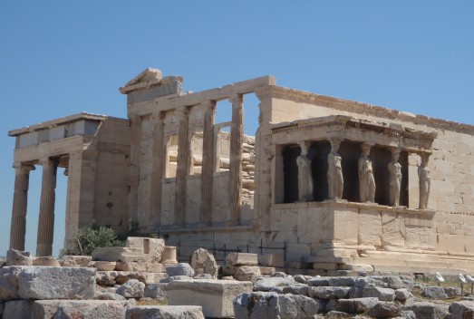
Erechtheion
This is a great system. There are three lines that cover much of the city. Some trains run above ground and some underground. It is quick, comfortable, and affordable. It took us less than 30 minutes to get across town and back to the port where we caught our ferry back to Aigina.
The next morning we took the slow ferry to Athens, and we much preferred it. We sat outside in the shade and had coffee. It was clean and comfortable.
Having had success on the metro the day before, we caught it to the Archeological Museum across town. Again, the metro was excellent.
When we got off, we walked toward the museum which is just beyond a large park. We immediately noticed many police – almost on every corner. All of them were carrying riot gear. At one point, we saw a pile of dozens of riot shields leaning up against a wall. It was obvious they were anticipating trouble. It was one week before the elections, and there was a lot of political activity on the streets. We were hoping it would not dissolve in to riots or chaos. We planned an alternate way out of town just in case.
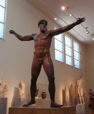
Zeus in the National Archeological Museum
The Archeological Museum building is a protected monument itself. It was founded in 1866, and it has continued to develop since. It houses and protects antiquities from all over Greece, and it is considered one of the ten best museums in the world.
Its collection can be loosely divided into four eras and a pottery collection. The eras include 1) Neolithic through Cycladic, 2) Mycenaean through Dark Ages, 3) classical, and 4) Hellenistic. In addition to the pottery collection, there was a traveling exhibition from the Antikythera Shipwreck while we were there.
The museum was everything we expected it to be and more. We expected an impressive collection; however, we were surprised by the quality of the displays. It pays tribute to the history, culture, and art of Greece.
The streets did not dissolve in to riots while we were in the museum, so we found our familiar way back to the metro. We were again back at the port within half an hour. We took a leisurely ferry ride back to Aigina, and we were ready to move on to the north.
This was a boring motorsail of 24 miles in 4 1/2 hours from Aigina to just outside the east end of the Corinth Canal. We anchored in the shadow (and stench) of an oil refinery with plans to transit the canal the next morning. We spent the night and headed to the canal in the morning.
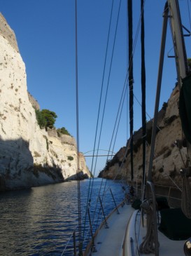
The Corinth Canal connects the Aegean Sea with the Gulfs of Corinth and Patras and eventually the Ionian Sea. It saves the trip south-west-north around the Peloponnisos Peninsula. The peninsula is technically a large island since the canal severed it from mainland Greece; however, it is still thought of as a peninsula of the mainland.
The canal was thought about for millennia before it was built. Previously, ships were dragged across the narrow isthmus. Roman Emperor Nero actually began to dig the canal in 67 AD, but his problems elsewhere diverted his efforts. The Greeks finally completed the canal in 1893.
The canal is only 3.2 miles long. It is also shallow (23’) and narrow (81’). Its dimensions restrict it use to only relatively small craft.
When we transited, we had one tug following behind us and no other vessels in front of us. It was a beautiful trip that was over all too soon.
The canal walls are vertical limestone. The shallow water is a turquoise blue. We immensely enjoyed this brief trip.
When we got through the canal, we decided to sail to Itea – another 30+ miles westward. At the end of the day, we had traveled 44 miles in 9 hours. Itea would be a convenient place from where we could visit the ancient site of Delphi.
Although our sail started out with light winds and calm seas, the seas got ugly about ten miles before Itea. We had no choice but to forge ahead, and we arrived in Itea barely remembering the wonderful experience we had in the canal just a few hours earlier.
Itea, like Chios, started a marina but never completed it. The concrete and bollards are there, so we tied up securely and waited out a small low pressure system that blew over.
We took the bus to visit the ancient site of Delphi. The bus took us to the charming town of Delphi on a spectacular hillside overlooking the valley below and the port of Itea.
Unfortunately, one cannot understand the significance of Delphi without some mention of Greek mythology. Delphi was believed to be the center of the universe. Legend has it that Zeus released two eagles from the ends of the earth. Their paths crossed above Delphi, and the spot was marked with a large egg-shaped rock. This was to be the site for the temple of Apollo who shared his wisdom through an oracle. Delphi was the religious and spiritual center of the ancient Greek world for centuries.
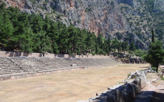
Stadium at Delphi
Delphi has been inhabited since Mycenaean times (14th to 11th centuries BC); however, the cult of Apollo arose during the 11th to 9th centuries BC. It reached its peak of importance in the 6th Century BC, and it was closed in 393 AD as Christianity grew.
Excavation began in 1892, and ruins include the temple, numerous treasuries, a theater, and a stadium that was the site of the Pythian games – somewhat of a precursor to the Olympic Games. There is now also a museum housing relics from the site.
We wanted to keep moving. On to Trizonia.
Having had an unpleasant arrival in Itea, we decided to leave early in the morning for Trizonia. We hoped to arrive before the afternoon winds and seas built. We traveled 22 miles in 4+ hours while conditions were still calm.
Along the way to Trizonia, we crossed our ‘half way’ point. At 0600 UTC we crossed over longitude 022.10 east – half way around the world from Honolulu. We each had a sip of ouzo and gave Poseidon a nip. We shook our heads in amazement over where we have been, where we are, and where we still have to go. Another sip of ouzo then onward…
Trizonia port/marina is another port where the concrete was poured for a marina, but no further development followed. As we approached, it appeared quite run down. Many of the boats appeared to be abandoned. A moderate sized ketch had sunk in one of the fairways. But we found a place to side-tie with the wind pushing us off the dock, so we were pleased to call it home for a few days. The wind did increase in the afternoon, but we were secure.
Trizonia is a small island – less than one square mile – and it is only 1/3 mile off the mainland coast. It is the only inhabited island in the Gulf of Corinth, and its population is very small. We were told that only 100 residents live on the island during the summer, and only 20 remain on the island year round. There are no motorized vehicles – no cars or scooters. There are only a few tourist oriented businesses – hotels and tavernas.
Reportedly Aristotle Onassis considered buying this island before buying Skorpios in the Ionian Sea. We can understand his desire to have it. It is a beautiful island. There are walking trails along the wooded shore and wildlife in the hills. Another herd of goats wearing bells came down to the water nearby. The tavernas were pleasant, and we were charmed by the local village. There is no shopping, police, health care, etc. However, a small boat operates as a frequent ferry across the small channel between the island and the mainland. A delightful stop.
Another early start to try to get in before the winds and seas create their daily aggravation. We traveled 38 miles in 6 3/4 hours to Messolonghi.
We passed under the Rhion Bridge just over three hours after leaving. This narrow strait separates the Gulf of Corinth in the east from the Gulf of Patras in the west. We continued on to Messoonghi.
Messologhi is a historically significant town, but the area did not appeal to us. Messolonghi is reached by traveling three miles up a dredged channel through salt marshes. There are stilt houses, fishermen, and birds along the way. At the end of the channel, there were limited options where to put Passage. There is no anchorage. There is a wall outside the marina, but it was full. So we went inside the marina.
It was hot, and there was little breeze so far inside. Also, the water was dirty and smelled bad. There were a few shops, but we needed nothing. The people were friendly, but the marina was unpleasant. We spent the night and moved on.
Going west through Corinth Canal
The history of the Ionian Islands is different from island groups further east. They were colonized by the Corinthians in the 8th century BC, and they became active in trade. Although the Turks never controlled the islands (except Lefkas), the islands were occupied by the Venetians, French, then British from 1363 until 1864 when they were ceded to Greece. Influence from those occupations remains.
The islands are green and fertile – a lovely contrast to the islands further east. Olive and cypress trees are common. Unfortunately, the islands also lie on a fault line, and they have experienced massive earth quakes.
We traveled 42 miles in 7 ¼ hours during which we left the Gulf of Patras and entered the Ionian Sea. We continued straight across the sea to the island of Cephalonia.
Cephalonia is the largest of the Greek Ionian islands. It is rugged and steep with its highest point at 5200 feet. The east side – where we went – is forested and mostly green.
The island has been inhabited since around 50,000 BC, and it is important in Greek mythology and in more recent history. During World War II, there was a massacre of Italians forces on the island that was a particularly heinous incident. And more recently, it was devastated by the Ionian earthquake in 1953. Almost everything on the island was built after that earthquake.
We went in to Eufimia Bay and anchored. The town quay was crowded with a charter flotilla (a new experience for us), but we were able to time our shore visit to avoid most of the madness. Not a bad experience being anchored some distance away.
We had the pleasure of meeting another American cruising couple – Steve and Karyn on SV Threshold – and really enjoyed them. Bud tried to fix an alternator problem they were having, but it turned out to be diodes that need to be replaced. We had a wonderful dinner on their boat, and we talked until midnight. We hope to cross wakes with them again.
The trip from Cephalonia to Ithaca was 18 miles which we covered in 3 1/2 hours. It was a very pretty trip. Both islands are rugged but green with indented coastlines. At Ithaca, we anchored in Vathi Bay. Again a charter flotilla came in to the town quay, but we were well away from them.
Ithaca, too, is important in Greek mythology. It has been inhabited since 4000–3000 BC. It, too, was mostly destroyed by the 1953 earthquake.
Vathi is the only main town on the island, and it has built up the hillsides around the harbor. It has been designated a “traditional settlement”, so new building matches the existing style. This ‘control’ has created a charming uniformity.
The town is the usual collection of shops and tavernas. We did, however, find more English spoken here than most places we have been – even by many of the older residents. Many young men here have worked as merchant seamen, and they have brought their language skills back to the island.
We have been searching for goat bells since our experience in Ormos Parapanta last month. Nita cannot leave Greece without a goat bell. We ask everywhere we go, and we get little response other than curious looks. But we had lunch at a nice little taverna, and our waiter spoke good English. He sent us to a hardware store down the street. They had goat bells! They also had sheep bells (we did not know there was a difference), but we wanted a goat bell.
There were three generations of males in this store, and the two older men spoke good English. The oldest had visited Honolulu in 1956 as a merchant seaman, and he had interesting stories to tell. The middle generation makes and collects knives, and he showed us some of his work. The youngest was a shy boy of about ten who did not speak to us.
They showed us a few different sizes of bells, and they all sounded different. We bought the largest goat bell they had (the largest goat bell is much smaller than the smallest sheep bell), and Nita’s excitement must have been obvious because the middle-aged man gave us another bell. He thought it was rather special to have sailors in his store that had sailed all the way from Hawaii and excitedly sought out goat bells. Nita was thrilled.
Before leaving Ithaca, we stopped at the fuel dock. We have been motoring and motorsailing almost constantly, and we do not know where we will next find a convenient fuel dock. We took on 77 gallons of diesel at the equivalent of $7.89 USD per gallon.
It was 38 miles to Meganisi, and it took us 5 hours. Meganisi is a traditional island with very little tourist infrastructure other than the one port of Vathi (a common name). There is reportedly one hotel on the island, but we did not see it.
We were looking for a little quiet, so we explored the bays on the north shore east of Vathi. Some were too crowded for us to anchor, so we continued west until we found a spot where we could anchor and shore tie without crowding our neighbors – or feeling crowded. It was a relatively peaceful anchorage; however, there were still more than 20 boats there overnight.
We had lots of small fish, birds, and wasps. Although this island is infamous for its wasps, they were not much of a bother. We put mosquito nets up at night anyways, so now they served double duty – mosquitoes and wasps.
We never went ashore. We spent a quiet night, slept in, and left in the morning.
When we got outside the bay we were happy to find 16 knots of breeze – and not directly on our nose. We put up the main and staysail and had a lovely sail. We traveled 7 miles in 1 1/2 hours to Lefkas.
We sailed by Skorpios which is the Onassis island. It is a beautiful island just a few miles off the coast of Lefkas – a much larger and busier island. We can understand why Ari liked this place so much. He and both of his children are buried there.
Lefkas was previously a peninsula, and it is an island only because of the man-made channel separating it from the mainland. The first channel was probably dug by the Corinthians around the 7th century BC. It was dug again by Augustus during the Roman occupation and later by the Ottomans. However, the present channel was built by the Greeks in the early 20th century.
The channel is just over three miles long. It is narrow and shallow, and it has a floating bridge at the northern end that opens hourly to allow boats through. But we went first to Vlikho Bay which is south of the canal.
We sailed in to Nidri on Lefkas Island. Nidri is a major charter center, and it was a bit chaotic with charter boats heading in all directions. But we headed south in to Vlikho Bay, and it was much calmer.
Vlikho Bay has long been popular with cruisers in the area, and there was a tragedy here last year with a few cruising boats. A tornado touched down in the bay. It knocked one man off his boat and killed him. It turned over a cruising catamaran from the UK and nearly killed the woman. She was somewhat miraculously rescued by a local man. And it destroyed other boats. But it was calm when we arrived.
Within the hour we heard from Steve and Karyn on Threshold – the couple we met just a few days ago in Cephalonia. They are waiting for their alternator to be repaired, and they are spending some time here. We had dinner ashore with them and said goodbye once again as they set sail in search of some breeze – it was terribly hot.
We had made arrangements to have our liferaft serviced further north in Lefkas town, and we had an appointment for June 25. So we had a few days to relax. We explored the town of Nidri, did laundry, bought a few provisions, cleaned up the boat a bit, etc. After a few days of ‘catching up’, we were ready to move on.
We traveled north for 10 miles in 2 ¼ hours to Lefkas town. Lefkas town provides boating services not found elsewhere nearby. There are three chandleries, a marina, a large town quay, and a decent anchorage. There are many charter boats based in Lefkas town, so there are also many hotels and tavernas. There are also two businesses that service liferafts, and that is why we went to Levkas town.
We had heard good things about Ionian Marine Safety, and we had exchanged a few e-mails with their manager, Nikos. We had an appointment to bring our liferaft in for service on June 25.
Our liferaft was purchased new in 1985, so it is 27 years old. We worry that it will not pass inspection every time we take it in, but we are always assured that it is a very good quality raft, and it has always passed. Again we worried. Again it passed.
Our raft was inspected, serviced, and repacked, and it was time to move further northward.
We went past the Santa Maura floating bridge at the north end of the Lefkas Canal, and we spent 7 1/2 hours traveling another 37 miles north to Gaios on Paxos Island.
Paxos is only five miles long and two miles wide. Its main income is from olive oil and tourism. Tripper boats come in during the day, and charter yachts come in in the evenings. We chose to anchor out to avoid all of these as much as possible.
A small island – Nisos Ay Nikolaos – of approximately 1,000 square meters sits in the center of Gaios harbor. It is an attractive thickly wooded island, and it is apparently the site of a seagull rookery. We have never seen nor heard so many gulls of all ages. There are thousands of them. Although sea gulls are not our favorite birds, this many of them do create a site.
We bought a few quarts of the expensive local olive oil, and we are ready to move north again to our final port in Greece – Corfu.
This was another long motor and motorsail with almost no wind. We spent 7 hours traveling 35 miles to arrive at Gouvia Marina just north of Corfu town.
Corfu was colonized by the Corinthians from 734 to 434 BC then by the Romans from 229 BC until 337 AD. The Byzantines ruled the island intermittently from 722 to 1386 AD with frequent assaults from various groups, and Corfu asked the Venetians to restore order. The Venetians ruled from 1386 until 1797, and the French ruled from 1807 until 1814. The British ruled from 1814 till 1864 when Corfu was ceded to Greece.
Today Corfu is a large and diverse island. It offers quiet beaches or rugged coast, developed resorts or traditional villages, mountains or coastal plains. It offers many choices, and consequently, it is busy and crowded with tourists.
As we approached the island, we saw one large cruise ship in port, and another was steaming in. Meanwhile, countless ferries and tripper boats came and went. It was alive with activity.
But we did not come to Corfu for activity. We came to check out of Greece. We spent a few days in the marina preparing ourselves and our boat for our next travels. We enjoyed the nearby village of Kontakali – relatively laid back. Then we faced Corfu town to check out.
Checking out was a somewhat frustrating experience – we were sent hither and yon back and forth – but we accomplished it within a few hours. We made a final grocery stop, and we left the marina.
Although one should leave the country after checking out, we knew we could not get across to Albania to check in that day, so we opted to make one more stop along the northeast shore of Corfu. We went in to almost every bay along the northeast coast, and none of them were suitable for overnight anchoring. Finally we came across Ayios Stefanos (another common name).
This is a lovely small bay. There are a few tavernas, but no large tourist infrastructure. We found a good spot to anchor amid a few other boats there ahead of us, and we decided to spend out last night in Greece there.
We went ashore and had a very nice experience. The locals were the friendliest we have encountered in Greece. We had a nice dinner at one of the tavernas. And we actually wished we had a bit more time to hike the trails that go around the point – surely a scenic hike. But we were already stretching the rules, and staying longer to go hiking would be a blatant violation. So we went back to the boat with our final night in Greece leaving a good impression on us.
Come along on our short sail from Greece to Albania or jump ahead to Albania.