SAN BLAS ISLANDS
The San Blas Islands are on the northeast coast of Panama. This is an autonomous area of the Kuna Indians, and they refer to this area as Kuna Yala.
The oral history of the Kuna place their origin in Sierra Nevada, Colombia, about 6,000 years ago. Physical evidence of pottery and jewels found in the Darien – previously Kuna territory – date to 500 BC. But their better known history began in 1501 when Columbus discovered Panama.
Panama’s first Spanish governor was Vasco Nunez de Balboa, and he got on well with the Kunas. However, his successor, Pedro Arias Davilla, executed Balboa and many of the natives.
Panama joined Colombia in 1821 seeking independence from Spain, but the Kuna (all of Panama) separated from Colombia in 1903. There was conflict between the Kuna faithful to Colombia and those not. Trying to resolve that conflict, Panama’s President Porras appointed a governor on El Porvenir in 1915, but the conflict worsened. The police were tying to suppress the Kuna customs, and that intensified the problems.
In 1925, the usually peaceful Kuna proclaimed the Republica de Tule, and they executed police and other Kuna that were less than full-blooded. In 1930, the US mediated a settlement that resulted in an autonomous Kuna reserve that became the Comarca de San Blas in 1938. That is now the Comarca de Kuna Yala.
The Kuna do not like the term ‘San Blas’. That is a name given to the islands by the Spanish. They refer to their territory as ‘Kuna Yala’, and they talk of Panama as though it is another country. They see themselves quite separate from Panama.
In 1953, Panama granted legal and administrative status to the Kuna, and in 1972 the Kuna elected their first members to the general assembly of Panama.
The Kuna resisted five centuries of invasions by the Spanish, French, English, and others including various groups proselytizing various religions. They are the only Amerindians who gained real autonomy of territory and the means to protect their traditions and culture.
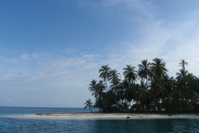
Kuna Yala was previously called Comarca de San Blas, and it was defined by the Carta Organica in 1953. It includes a 1,235 square mile strip of land along the Caribbean coast of Panama. It stretches 122 miles from Puerto de Obaldia in the east (the border with Colombia) to Punta San Blas in the west. All islands of the archipelago de San Blas – more than 350 – belong to this territory. Only 49 of the islands are inhabited.
The islands go by various names. Some have Kuna names (ex. Olosicuidup), some have Spanish names (ex. Isla Maquina), and some have English names (ex. BBQ Island). And some are know by more than one name. It can be a bit confusing to all but the locals.
The population of Kuna Yala is slightly more than 50,000. This is about ten percent of the pre-invasion population.
Most live in settlements near the mouths of 20 main rivers along the coast. Most of the population has moved from the mainland to the islands to get away from the mosquitoes and snakes, but most men travel to the mainland daily to work their gardens in the jungle. In addition to the island communities, there are still eight small Kuna communities on the mainland, two in the Darien, and two in Colombia. Approximately one third of the population travels to work in Panama City, Colon, or Changuinola.
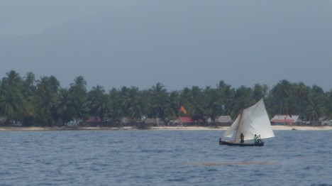
The Kuna travel around the islands and up the mainland rivers in canoes called ulus. Ulus are built from a single tree and paddled. They are mostly very attractive boats.
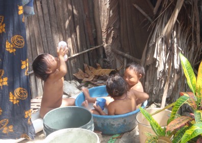
The Kuna are small in stature. Only the African pygmies are smaller. And they are remarkably healthy with a near absence of common western diseases such as cancer and cardiovascular disease. However, they have a very high incidence of albinism that is attributable to their small gene pool.
The Kuna have their own language, and it is spoken by all Kuna. Most men also speak some Spanish, and only a few speak any English. Most that speak any English have some connection to the tourist trade.
The Kuna are a closed society. Kunas are not allowed to marry anyone other than another Kuna. Those that marry a non-Kuna will be expelled from the society. Non-Kuna are welcome to visit Kuna Yala, but they cannot buy property or remain beyond what the village authorities consider a reasonable holiday time.
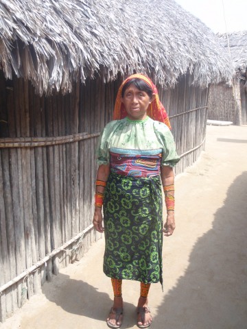
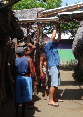
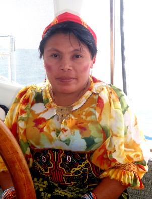
Kuna men have adopted western dress, but almost all Kuna women continue to wear their traditional dress. They wear a mola blouse, skirt, red and yellow head scarf (moswe). They wear beads (wini) on their arms and legs, a gold ring through their nose, and a black line down their nose.
Most Kuna live a subsistence lifestyle. Men tend gardens in the mainland jungle, and women sew molas. Molas are a major source of income for the Kuna. We certainly make our contribution to the Kuna economy via molas.
The islands stretch approximately 122 miles from east to west. We explored only the westernmost 25 miles.
Mid-day on our second day there, four boats came in. One was a low budget tourist boat with 28 twenty-somethings on board. They ran aground on the reef, and they asked their passengers to jump overboard to lighten ship. Some chose to swim ashore near our boat. The first few ashore were bellowing about their lack of beer, so Bud jumped in the dinghy and took them two six-packs that we had on board to give away. Bud was a hero. Soon he was ferrying scantily-clad young women around the anchorage. A true hero. They got off the reef a few hours later.
That night – our second there – Bud slept up in the cockpit for a while. Something woke him, and he sat up to find a stealth military boat about ten feet from our boat. It was a very dark night with no moon, but he could see that the boat was all black with four crew all in black including hoods, masks, flak jackets, and night vision goggles. They went to the back of our boat and wrote something down, then they left. A very strange event.
This anchorage was a wonderful introduction to these islands, and we looked forward to seeing more. But we decided to make a ‘functional’ stop – laundry, food, phone – at Nargana before heading further west and visiting more offshore islands. Off to Nargana.
We motored six miles to Nargana – the largest village in this area. There are two things one notices about Nargana right away – trash and sewage. There is seemingly no effort at all to contain trash. It is either dropped where one is standing or thrown in to the water. They have a real trash problem. And each house has its own outhouse that is a direct drop in to the water. You must be careful where you tie up your dinghy.
We started by trying to get a SIM card for our phone and possibly internet access. We asked around and found the phone ‘office’ – a table behind a chain link fence. While buying our SIM cards, Federico arrived and introduced himself. Federico has a laundry service and acts as a guide in the river and jungle. He made a lunch recommendation (very good), and we arranged a trip up the river in to the jungle later that afternoon.
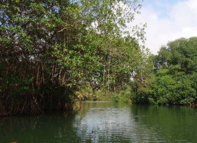
We motored one hour up the Rio Diablo. It was a pretty trip, but it would be nicer if someone would drag away the countless tree limbs that clutter the way and endanger inflatable boats like our dinghy. We went ashore and hiked only an hour in to the jungle. Pretty but nothing particularly interesting. Bud and Federico swam and washed in the river before heading back downriver.
We gave Federico our dirty laundry and asked him to wash it in the morning. We planned to pick it up wet and move to another island to hang it out to dry.
We spent a few hours trying to get the phone and internet working, but we failed on both. Obviously we needed to return to the phone ‘office’.
In the morning, we started with the phone, and we were not successful. Apparently the Panama Digicel cards will not work in either of our international phones. Nor will the internet work in our Digicel stick. Oh well… We also bought a few veges and a chicken, and we picked up our wet laundry. The trash and sewage was too much for us, and we were ready to move on – to Kanlildup.
We motored only six miles to Kanlidup, but it was a world away. This is an uninhabited island behind a protective reef. There were six other boats there when we arrived. Unfortunately, there was very little wind, and it was uncomfortably hot. But we got our laundry on the line, and made plans to go in search of more breeze the next day.
A Kuna couple – Prisciliano and Adelaida from Isla Maquina – paddled up to our boat selling molas. We were impressed with her work, and we bought two. Isla Maquina is the first island where Nita wanted to shop for molas, but Bud was not yet ready to return to ‘civilization’ after experiencing Nargana, so we planned our next stop further north in the Holandes Cays.
The Holandes Cays are the northernmost group and are farthest from the mainland, so they have the cleanest water of all the islands. We motored nine miles to the northeast corner of the cays to an anchorage commonly called the Swimming Pool because of its water clarity. We anchored just west of BBQ Island – a name given because of its frequent barbecues by cruisers.
The water was ok, but it was not what we expected. There was a lot of grass floating, and it seemed a bit murky. We don’t know why it was not as clear as its reputation claims, but it was clear enough that we could again see rays and fish swimming all around us. And we had 6 to 7 knots of wind – enough to cool us a bit.
A power boat came in to the anchorage in the morning and collected a $10 mooring fee from us. The winds increased to 10 to 11 knots, and we were cool enough that we went exploring. We went ashore on BBQ Island (charged $2 each) where two young men live a very basic life. Nita cut Bud’s hair and we walked the entire island in a few minutes. There were vertebrae from a very large whale there. And we took advantage of the cool breeze and explored a bit in the dinghy.
But the molas were calling Nita. She wanted to go to Isla Maquina and do some serious shopping. We left after two nights in the Swimming Pool.
We motorsailed 17 miles to Isla Maquina. In the Kuna language, this island is called Mormaketupu which means ‘mola making island’. We had seen the work of a mola maker here – Venancio – and we knew we wanted to see his molas. Fortunately Venancio and his brother, Idelfonso, came to visit us almost immediately as we arrived.
We spent a few hours in Passage’s cockpit looking at Venancio’s molas, and we bought far too many. Later we went ashore for a tour of the village.
There are 250 people living in 44 houses built of reeds with thatch roofs. The houses have no furniture other than hammocks. They have solar panels providing some electricity, and water runs from the nearby river. They cook over wood. It is a clean and tidy village with no trash in sight. They do, however, also have direct drop toilets over the water.
There is an election this week, but we did not understand what it is about (We later learned that it was a presidential election.). But colorful flags and banners were all around the village, and the atmosphere was festive. We enjoyed watching them playing pan flutes and dancing – not for our entertainment but for theirs.
The other island where Nita wanted to shop for molas was Rio Sidra. We have also seen the work of Lisa on Rio Sidra, and we wanted to buy a few of her molas. However, Lisa did not come out to Passage, so we assumed that she was off-island selling her wares elsewhere. We were disappointed that we did not get to meet Lisa and see more of her work, but we had already bought too many and spent too much money, so we decided to move on rather than wait around until Lisa returns to her island. We headed to Isla Gunboat in search of some cooling breeze.
We motored only four miles to Isla Gunboat which is a small island with a large protective reef. We entered the lagoon over a reef only 12′ deep as we held our breath and hoped our charts were accurate. We made it in without a bump. Shortly after anchoring, a boat came out and collected $10 from us for anchoring.
Although we have had lots of clouds since arriving here, we have not had rain until now. It rained – hard at times – through the night. Then it was cooler the next day. What relief! We took advantage of a rainy day to catch up on some chores on the boat.
We spent a second night at Isla Gunboat and planned to head west to Isla Porvenir – our last stop in San Blas. We saw a small boat heading directly toward us, and it was Lisa from Rio Sidra! She had seen us when we went to her island two days prior, but she did not have a boat to come out to see us. So she came and found us at Isla Gunboat. With her was her niece and her niece’s two children. She gave us some bananas, and we looked at her molas and bought just a few. Lisa left for another island, and we left for Isla Porvenir.Isla Porvenir is at the western end of the San Blas Islands. We went there to check in to Panama. (Yes, we have been here for more than a week already, but the federalies are ok with west bound boats spending time in the islands before checking in.) When we got over the sticker shock ($393 USD) we went for lunch at the only business on the island, and it was very good. We enjoyed the cooling effect of a little rain.
We were sitting in the cockpit enjoying the cool of the evening a few hours after dark when we heard a boat nearby. We now had nearly a quarter moon, so it was not completely dark. We looked around and saw the stealth military boat again – headed our way. They hung around Passage’s port quarter and stern for about half an hour. They were 50 to 150 feet away. They never made any contact with us, and they left.
We were preparing to leave the next morning when Bud saw the boat at a nearby dock. We were going to dinghy over to take a look, but they motored by us – this time without stopping. A few military guys were on board, and they acted oblivious to us. It seemed less ominous by daylight, but we still feel a bit harassed. Why are they so concerned about Passage?
We left the harbor shortly before 10:00 AM local time and headed west. We have a date with the Panama Canal, but first a few days’ sailing along the Costa Arriba.
Return to our Panama page
Follow us to the Costa Arriba
or jump ahead to the Panama Canal
or the Las Perlas Islands